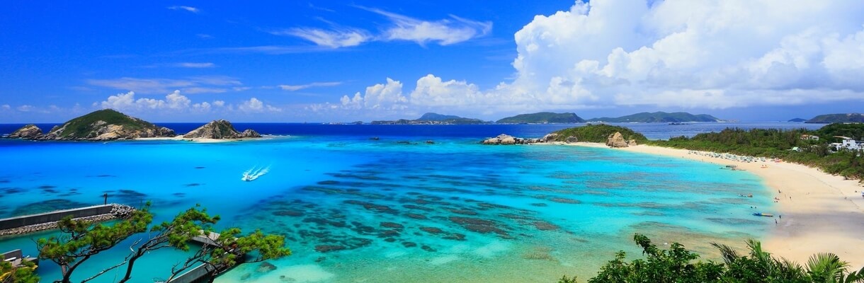

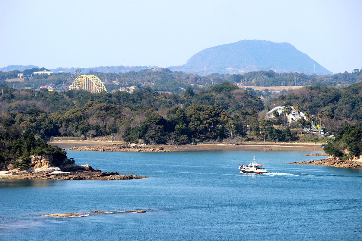
Unzen Amakusa National Park covers parts of Nagasaki, Kumamoto and Kagoshima Prefectures and is full of contrasts. It is divided into two areas: Mount Unzen Area represented by the mountainous Shimabara Peninsula created by repeated volcanic activity about 400,000 years ago and dominated by Mount Unzen, and the Amakusa area, a stunning archipelago of around 120 islands where you can see dolphins, corals, subtropical fish or enjoy such activities as snorkelling, diving and wakeboarding.
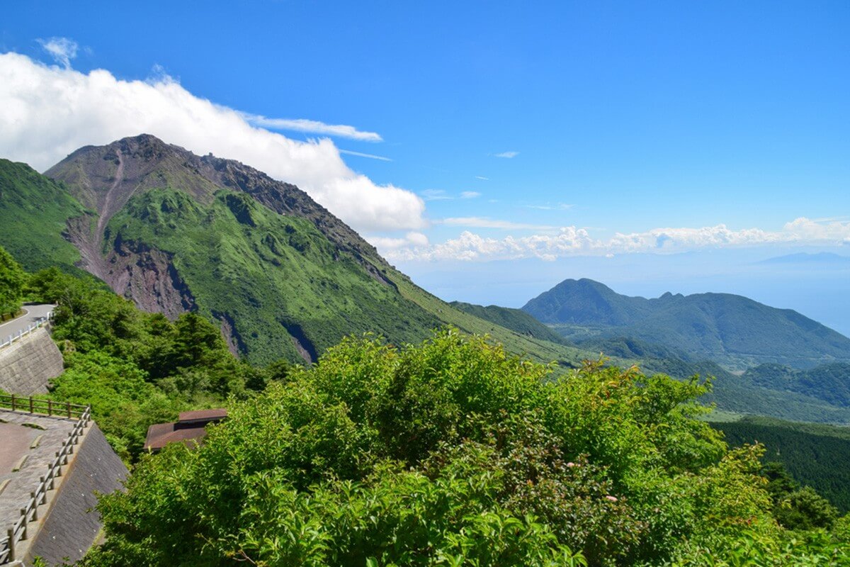
In the centre of Mount Unzen Area stands the imposing Mount Unzen, an active volcano made up of several stratovolcanoes. The pyroclastic flows from its most recent eruptions between 1990 and 1995 formed a new volcano, Mount Heisei Shinzan (1,483 m). Despite its reputation for destruction, more
In the centre of Mount Unzen Area stands the imposing Mount Unzen, an active volcano made up of several stratovolcanoes. The pyroclastic flows from its most recent eruptions between 1990 and 1995 formed a new volcano, Mount Heisei Shinzan (1,483 m). Despite its reputation for destruction, more
Mount Unzen is a place of astounding natural beauty. In spring, you can see its slopes covered in pink azaleas and Japanese flowering dogwood, while in summer, you can look for the Narcissus flycatchers that migrate to the area. Due to its high elevation, Mount Unzen is also one of the few autumn colour spots in Kyushu.
The visitors to Mount Unzen can drive as far as the Nita-toge Pass, from where the Unzen Ropeway leads part way up the mountain slope. The observation decks at the lower and upper ropeway stations offer impressive views over the surrounding mountains and the Ariake Sea on a clear day. You can start a hiking trail that leads up the mountain or take a cable car. A popular hiking route leads from the upper ropeway station along the ridge to Mount Fugen (1,359 m), the highest peak that you can reach. While Mount Heisei Shinzan is off-limits because of unstable lava blocks, you can view its smoking peaks by hiking up to Mount Fugen.
A little way down the Nita-toge Pass lies Unzen Onsen, a hot spring town that has nice baths, interesting hot spring fields and provides accommodation as well as convenient access from Shimabara city, Nagasaki and Fukuoka, making it a good base for climbing Mount Unzen. If you come from Shimabara city, visit the snow-white Shimabara Castle, originally built in 1624 and try Shimabara somen noodles, a local specialty prepared with water from Mount Unzen and sea salt from the Ariake Sea.
Amakusa Area includes three main islands - Shimoshima, Kamishima and Oyano that are connected by bridge to Kumamoto mainland. The connection with the smaller islands is provided by ferries. This archipelago rose out of the ocean bed about 47 million years ago and continues to transform. The Amakusa Islands offer you the possibility to see corals, dolphins, turtles and other creatures. You can go fossil hunting near Goshoura Cretaceous Period Museum on Goshoura Island, which is a treasure trove of dinosaur and marine clam fossils or you can head to Mount Takabuto on Kamishima Island, which is a great place to view the sunset. Shimoshima Island offers you the possibility to catch the sight of wild migratory birds such as the hooded crane and white-naped crane. While visiting Jusanbutsu Park you will see the massive elephant-shaped rock called Myokeniwa rising out of the deep blue waters. For a taste of history, you can visit Sakitsu Church, originally built in 1873 in gothic style when the ban on Christianity was lifted.
Established in 1934, Aso-Kuju National Park is one of the oldest national parks of Japan and was named after the active volcanoes of Mount Aso and the Kuju Mountains. Furthermore, it includes Mount Yufu, which overlooks Yufuin Onsen and Mount Tsurumi above Beppu located in its northern part. The park is one of the best places in Japan to hike or drive through dramatic volcanic landscapes and take in the views of the turquoise-blue crater lake of Mount Nakadake. You can go horseback riding, scale mountains, explore the vast pastoral grasslands filled with flowers and soak in the steamy hot springs.
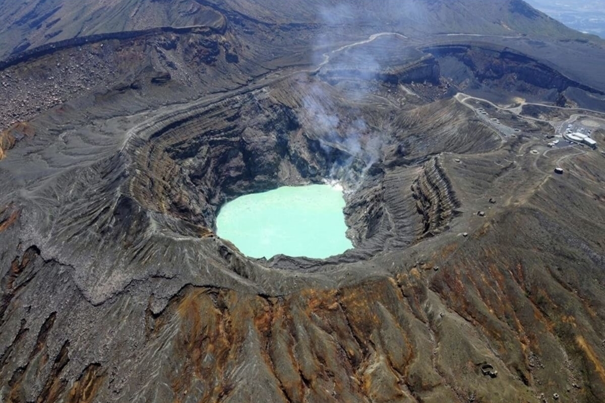
Mount Aso Area is dominated by the majestic peaks of Mount Aso, a large active volcano in the centre of Kyushu. The caldera of Mount Aso was created by multiple gigantic eruption in the distant past and is one of the largest calderas in the world with a diameter of up to 25 kilometres and a circumference of over 100 kilometres. more
Mount Aso Area is dominated by the majestic peaks of Mount Aso, a large active volcano in the centre of Kyushu. The caldera of Mount Aso was created by multiple gigantic eruption in the distant past and is one of the largest calderas in the world with a diameter of up to 25 kilometres and a circumference of over 100 kilometres. more
In the centre of the caldera stand the five peaks of Mount Aso. One of them, Mount Nakadake offers an impressive view of a turquoise-blue crater lake. The crater of Mount Nakadake is an acidic pool of pale turquoise-blue colour from which smoke and steam constantly rise. The crater area is accessible to tourists, but sometimes due to poisonous volcanic gases, bad weather or the risk of volcanic activity, it gets partially or completely closed.
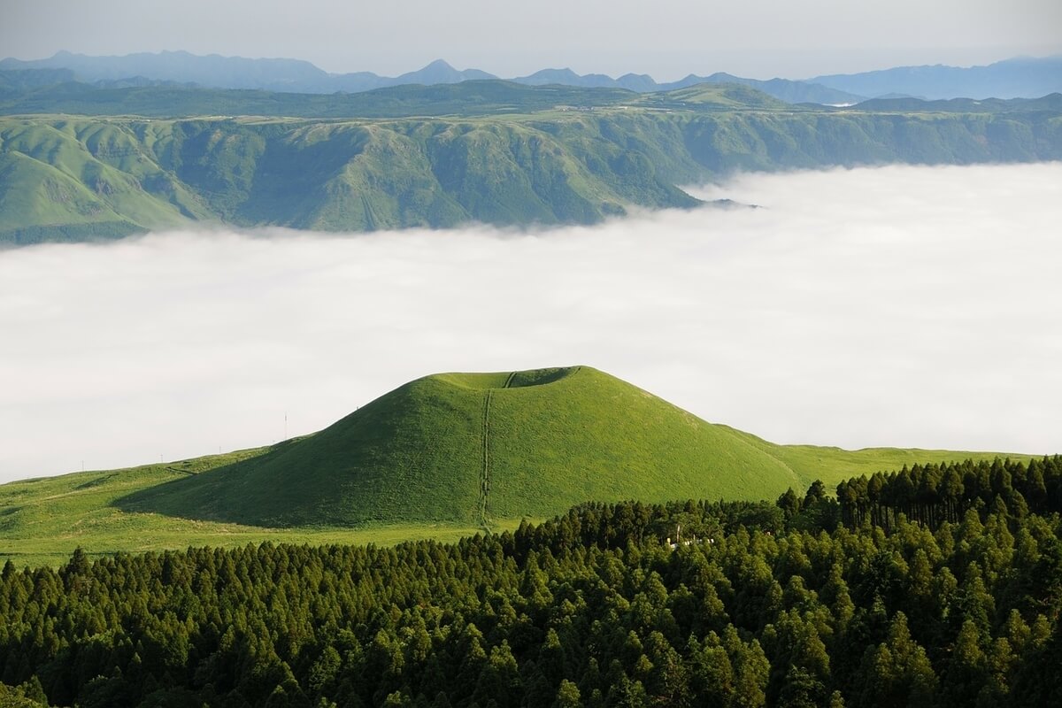
Not far from Nakadake crater is Kusasenri, a grass-covered plain with grazing cows and a few horses. On the opposite side of the road stands the Aso Volcano Museum where you can find more about the volcano and Nakadake Caldera. On the northern slopes of Nakadake is Komezuka, an almost perfect volcanic cone standing 80 meters high. To the south, you will find Shirakawa Suigen Spring that is very popular due to its pure water considered one of the best tasting in Japan. It was selected as one of top 100 Exquisite and Well-conserved Waters in Japan by the Ministry of Environment.
Kuju Mountains Area has an extensive number of hiking trails and is particularly popular in early summer when azaleas are in full bloom. Situated on the eastern edge of Kuju Volcano Group, Mt. Taisen is a nice spot to view the pink Kyushu azaleas that are in bloom from the end of May to the middle of June. Kyushu azalea colonies that grow on Mt. Taisen were designated a National Natural Monument in 1961.
Kuju Bogatsuru and Tadewara Marshes are two intermediate moors formed from the springs at the foot of Mt. Kuju. Both are wetlands recognized as Ramsar Sites of International Importance and have a wide variety of plants and animals. At Tadewara Marsh, you can enjoy the view of globe thistles and star lilies in the summer.
At the north of the marshes, you can find Kurodake Nature Forest, a dense grove of beech, elm, maple and other species of trees covering the slopes of Mount Kurodake and offering a spectacular sight of fresh verdure in the spring and autumnal foliage in the fall. This area is also famous as the location of Oike Pond, Shiramizu Mineral Spring, Kakushimizu and other famous waters in and around the starting point for climbing up the peak.
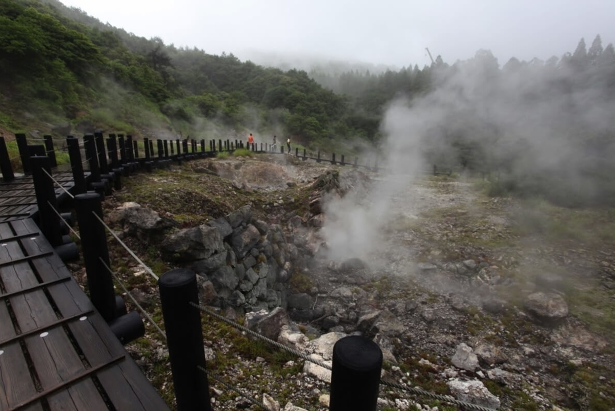
Another fascinating walking course takes you around Komatsu Jigoku site, which is full of steaming mini-craters and bubbling, sulphurous ponds. A wooden path on stilts with handrails allows visitors to safely observe them and see the unique scenery where hot water, water vapour, and mud spout out.
Mount Yufu and Mount Tsurumi are situated in the northern part of Aso-Kuju National Park. Mount Tsurumi (1,374 m) has been referred to as a sacred mountain since ancient times. Its summit houses a number of statues and shrines and is accessible by ropeway or on foot. On clear days, you can enjoy stunning panoramic views of Beppu Bay, Mount Yufu and the Kuju Mountains from here. At the summit of Mount Yufu (1,583 m), you will enjoy panoramic views of the hot spring towns of Beppu and Yufuin. The hike up takes about two hours but after that, you can soak your weary legs in the mineral-rich hot springs located at the base of the mountain.
Not far from Nakadake crater is Kusasenri, a grass-covered plain with grazing cows and a few horses. On the opposite side of the road stands the Aso Volcano Museum where you can find more about the volcano and Nakadake Caldera. On the northern slopes of Nakadake is Komezuka, an almost perfect volcanic cone standing 80 meters high. To the south, you will find Shirakawa Suigen Spring that is very popular due to its pure water considered one of the best tasting in Japan. It was selected as one of top 100 Exquisite and Well-conserved Waters in Japan by the Ministry of Environment.
Kuju Mountains Area has an extensive number of hiking trails and is particularly popular in early summer when azaleas are in full bloom. Situated on the eastern edge of Kuju Volcano Group, Mt. Taisen is a nice spot to view the pink Kyushu azaleas that are in bloom from the end of May to the middle of June. Kyushu azalea colonies that grow on Mt. Taisen were designated a National Natural Monument in 1961.
Kuju Bogatsuru and Tadewara Marshes are two intermediate moors formed from the springs at the foot of Mt. Kuju. Both are wetlands recognized as Ramsar Sites of International Importance and have a wide variety of plants and animals. At Tadewara Marsh, you can enjoy the view of globe thistles and star lilies in the summer.
At the north of the marshes, you can find Kurodake Nature Forest, a dense grove of beech, elm, maple and other species of trees covering the slopes of Mount Kurodake and offering a spectacular sight of fresh verdure in the spring and autumnal foliage in the fall. This area is also famous as the location of Oike Pond, Shiramizu Mineral Spring, Kakushimizu and other famous waters in and around the starting point for climbing up the peak.
Another fascinating walking course takes you around Komatsu Jigoku site, which is full of steaming mini-craters and bubbling, sulphurous ponds. A wooden path on stilts with handrails allows visitors to safely observe them and see the unique scenery where hot water, water vapour, and mud spout out.
Mount Yufu and Mount Tsurumi are situated in the northern part of Aso-Kuju National Park. Mount Tsurumi (1,374 m) has been referred to as a sacred mountain since ancient times. Its summit houses a number of statues and shrines and is accessible by ropeway or on foot. On clear days, you can enjoy stunning panoramic views of Beppu Bay, Mount Yufu and the Kuju Mountains from here. At the summit of Mount Yufu (1,583 m), you will enjoy panoramic views of the hot spring towns of Beppu and Yufuin. The hike up takes about two hours but after that, you can soak your weary legs in the mineral-rich hot springs located at the base of the mountain.

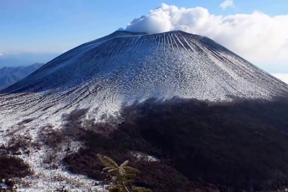
Kirishima-Kinkowan National Park in southern Kyushu is full of volcanic wonders, crater lakes, hot springs, sandy beaches and sites imbued with folklore and myth. Since ancient times, the sulphur and hydrogen carbonate hot springs in Kirishima-Kinkowan area known for their quality, have attracted locals and visitors looking to relax and rejuvenate. If you visit the park, don’t miss taking a unique hot sand bath in Ibusuki Onsen district, birdwatching around Rokkannon-Miike Crater Lake and viewing Mount Shinmoe, an active volcano, from the peak of Mount Karakuni.
Kirishima area that makes up the northern end of the park is dominated by Kirishima active volcanic mountain range and has more than 20 large and small volcanoes, as well as a number of crater lakes, hot springs and lava plateaus. more
Kirishima area that makes up the northern end of the park is dominated by Kirishima active volcanic mountain range and has more than 20 large and small volcanoes, as well as a number of crater lakes, hot springs and lava plateaus. more
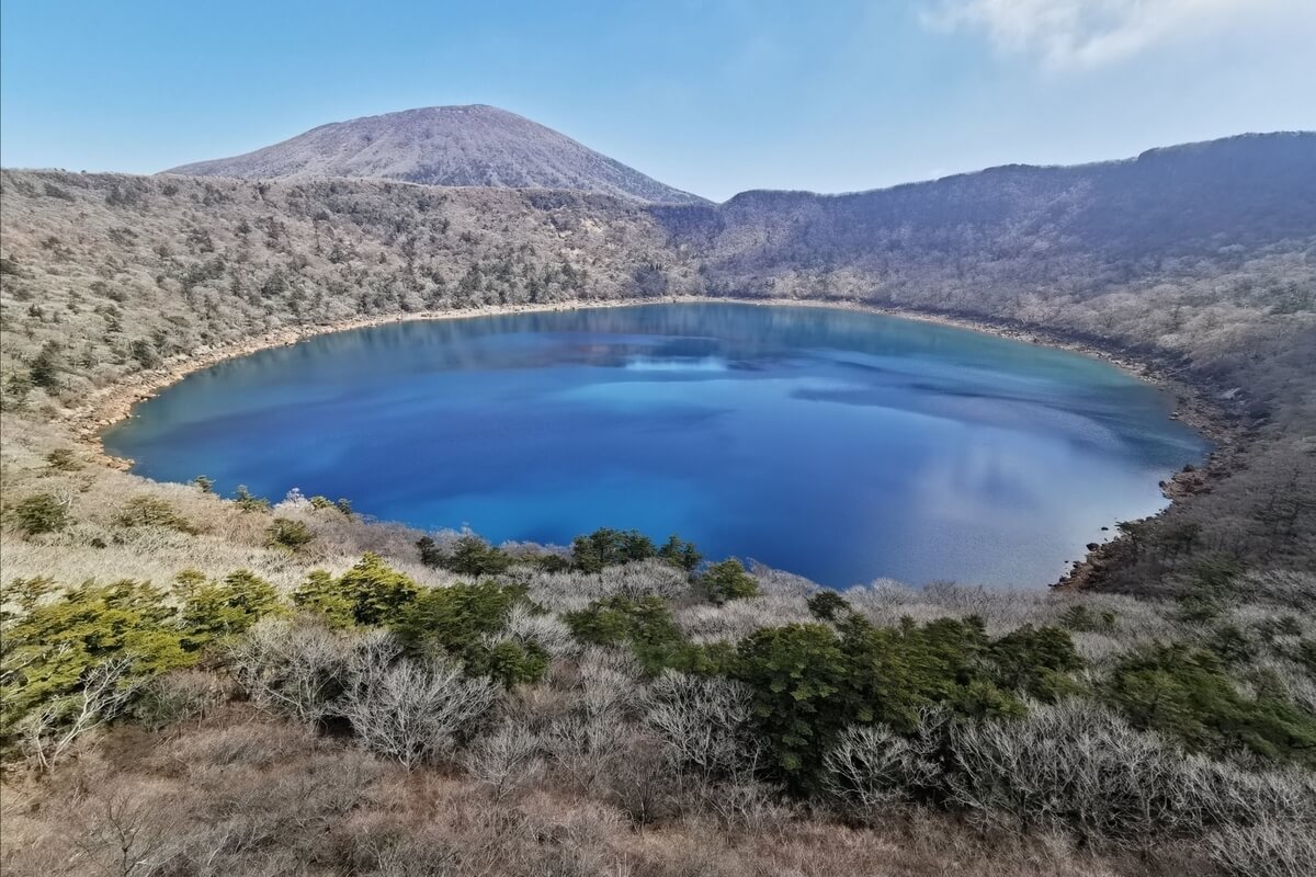
Mount Karakuni (1,700 m), which is the highest peak of the park, offers impressive views from its summit on clear days allowing you to see Kinkowan Bay, Mount Sakurajima and Mount Shinmoe.
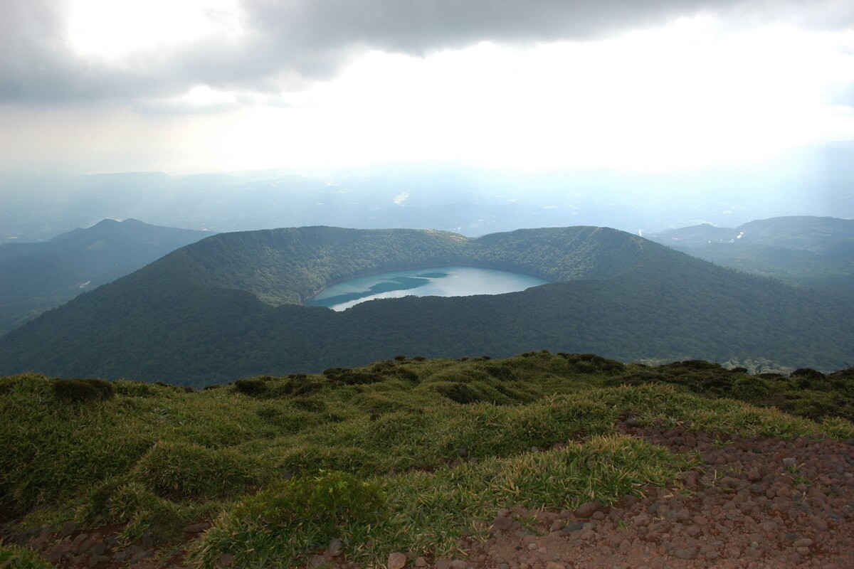
At the base of Mount Karakuni sits Onamiike Crater Lake. Located at an elevation of 1,239 metres, the crater lake of Mount Karakuni ranks as the highest in Japan. The circumference of the crater is about 1.9 kilometres, and you can circle it in about 90 minutes. The walk is lovely in spring when the spider-shaped flowers of Japanese witch hazel bloom here, in summer when the vivid pink blossoms of rhododendrons and Kyushu azaleas colour the area and in autumn when you can enjoy the colourful autumnal foliage onshore. In winter, the lake tends to freeze over completely. Another crater lake in Kirishima area that may be of interest to visitors, especially birdwatchers, is Rokkannon-Miike Crater Lake. You can camp by the lake, spend the day kayaking or watching wild birds including ruddy kingfisher and Mandarin duck.
Kirishima Onsen Village is also an important tourist attraction in Kirishima area. It has nine hot springs offering various therapeutic qualities. Ebino Kogen and Kirishima Onsen are two of the most prominent resort towns in Kirishima area. Ebino Kogen on Miyazaki side of the border is a small village with a couple of hotels and the perfect starting point for hiking in the park, offering hikes to the top of the mountains or around volcanic lakes. Kirishima Onsen on Kagoshima side is a more developed hot spring town with pleasant baths and nice views over Kagoshima Prefecture.
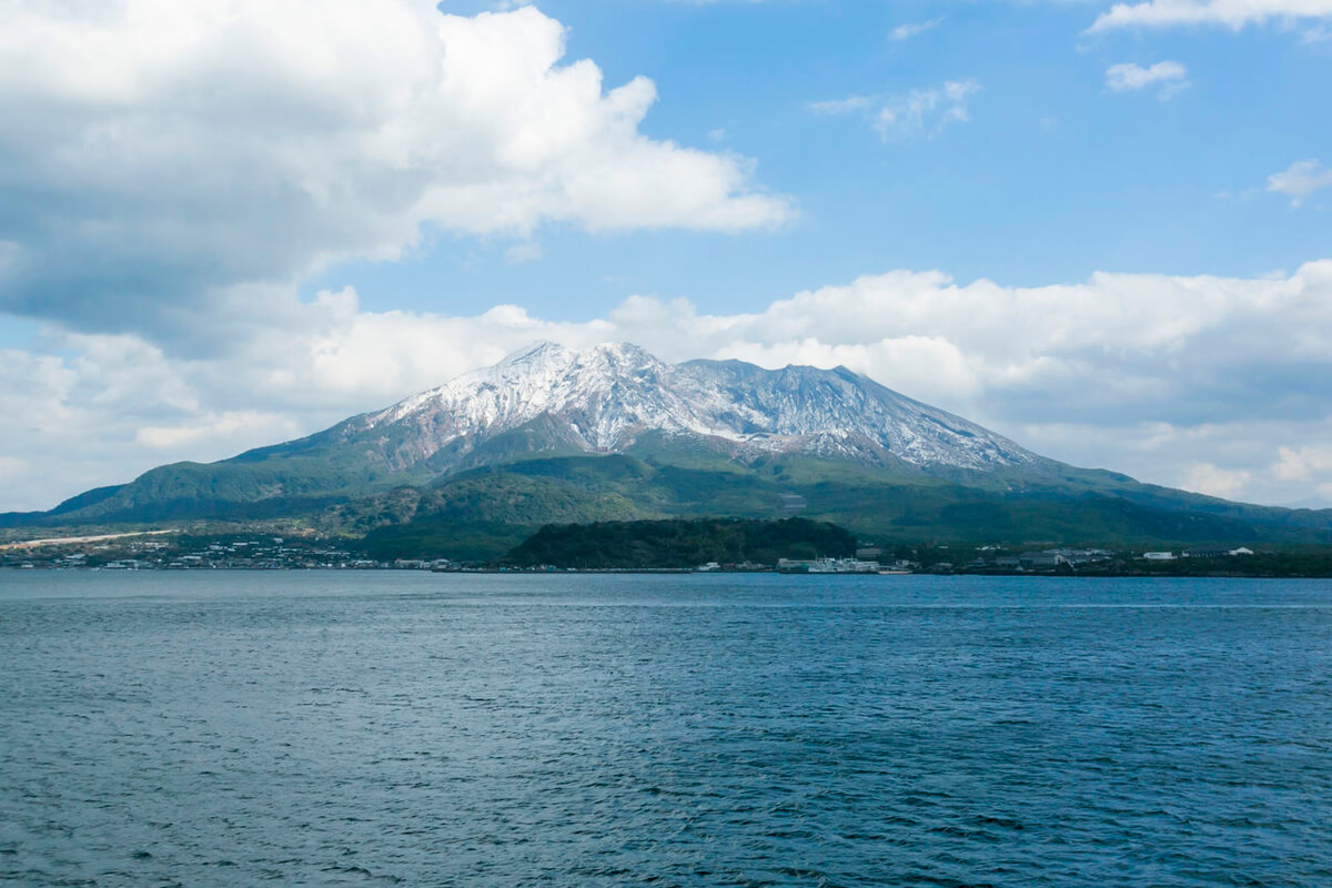
Kinkowan Bay Area makes up the southern part of the park. The bay was formed by a huge volcanic explosion about 29,000 years ago. The symbol of Kinkowan Bay is Mount Sakurajima, an active volcano that can often be seen spewing smoke and ash. You can get an unobstructed view of the mount from the top of Takatoge Pass, a spot also known for azaleas in spring. Shigetomi Beach, an amazing white-sand beach surrounded by stretches of pine trees, forms the shore of Kinkowan Bay.
Further south, on the tip of the Satsuma Peninsula you will find Ibusuki Onsen known especially for the sand baths. The hot springs that well up throughout the city have a high temperature of about 80 - 90℃ degrees.
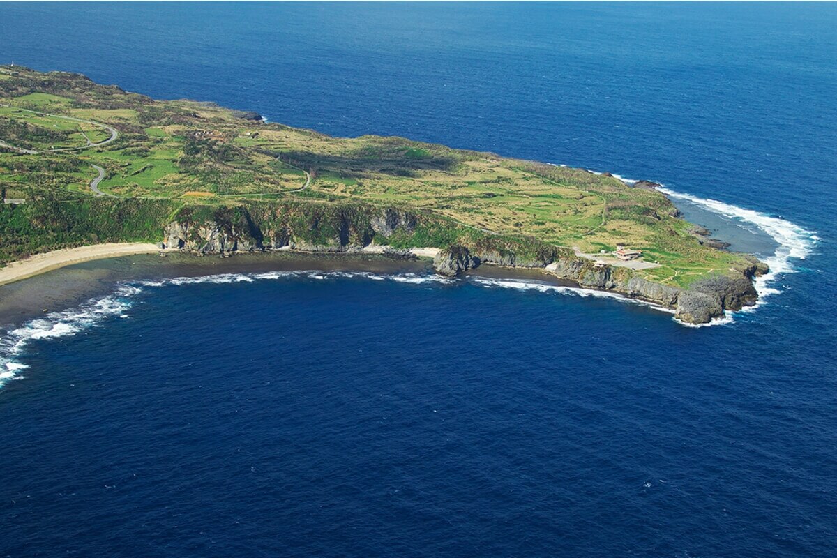
On the opposite side of the bay, you will see the rocky cliffs of the Cape Sata, which is the southernmost point of Japan mainland. From the cliffs of the Cape Sata you can see beautiful views of the blue waters, dolphins and a lighthouse built in 1871 that was designed by Scotsman Henry Brunton.
At the base of Mount Karakuni sits Onamiike Crater Lake. Located at an elevation of 1,239 metres, the crater lake of Mount Karakuni ranks as the highest in Japan. The circumference of the crater is about 1.9 kilometres, and you can circle it in about 90 minutes. The walk is lovely in spring when the spider-shaped flowers of Japanese witch hazel bloom here, in summer when the vivid pink blossoms of rhododendrons and Kyushu azaleas colour the area and in autumn when you can enjoy the colourful autumnal foliage onshore. In winter, the lake tends to freeze over completely. Another crater lake in Kirishima area that may be of interest to visitors, especially birdwatchers, is Rokkannon-Miike Crater Lake. You can camp by the lake, spend the day kayaking or watching wild birds including ruddy kingfisher and Mandarin duck.
Kirishima Onsen Village is also an important tourist attraction in Kirishima area. It has nine hot springs offering various therapeutic qualities. Ebino Kogen and Kirishima Onsen are two of the most prominent resort towns in Kirishima area. Ebino Kogen on Miyazaki side of the border is a small village with a couple of hotels and the perfect starting point for hiking in the park, offering hikes to the top of the mountains or around volcanic lakes. Kirishima Onsen on Kagoshima side is a more developed hot spring town with pleasant baths and nice views over Kagoshima Prefecture.
Kinkowan Bay Area makes up the southern part of the park. The bay was formed by a huge volcanic explosion about 29,000 years ago. The symbol of Kinkowan Bay is Mount Sakurajima, an active volcano that can often be seen spewing smoke and ash. You can get an unobstructed view of the mount from the top of Takatoge Pass, a spot also known for azaleas in spring. Shigetomi Beach, an amazing white-sand beach surrounded by stretches of pine trees, forms the shore of Kinkowan Bay.
Further south, on the tip of the Satsuma Peninsula you will find Ibusuki Onsen known especially for the sand baths. The hot springs that well up throughout the city have a high temperature of about 80 - 90℃ degrees.
On the opposite side of the bay, you will see the rocky cliffs of the Cape Sata, which is the southernmost point of Japan mainland. From the cliffs of the Cape Sata you can see beautiful views of the blue waters, dolphins and a lighthouse built in 1871 that was designed by Scotsman Henry Brunton.
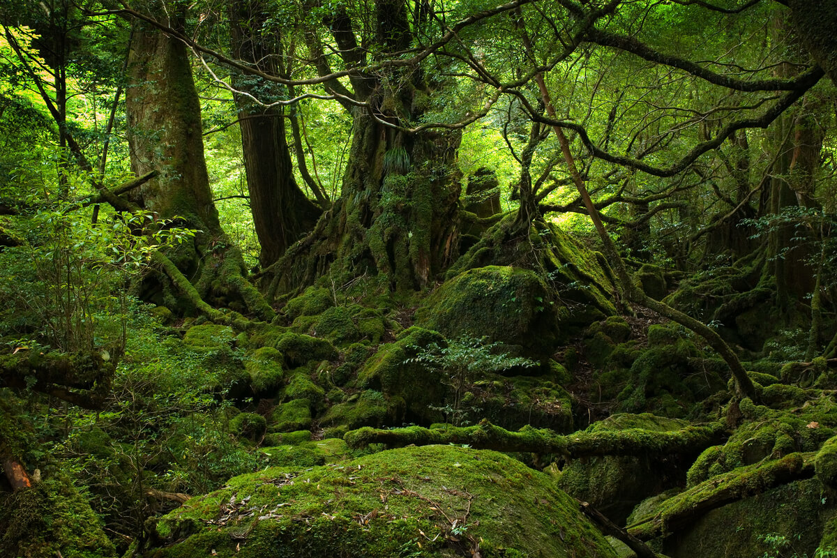
Yakushima (Island) National Park encompasses two very different islands. The larger one, Yakushima, is a subtropical island off the southern coast of Kyushu located about 135 kilometres south of Kagoshima. It is a mountainous island covered with dense cedar forests, which contain some of Japan’s oldest living trees – Yakusugi. They are large old-growth cryptomeria trees estimated to be somewhere between 2,000 and 7,500 years old. The smaller island, Kuchinoerabujima, is dominated by active volcanic peaks including Mount Furudake and Mount Shindake.
Yakushima, which is around 25 kilometres in diameter, has more than 39 mountains with peaks higher than 1,000 metres. At the centre of the island, you will find Mount Miyanoura (1,936 m), the highest mountain in Kyushu. You can take any path at Shiratani Unsuikyo Ravine and experience the otherworldliness of the ancient woodlands of the island. more
Yakushima, which is around 25 kilometres in diameter, has more than 39 mountains with peaks higher than 1,000 metres. At the centre of the island, you will find Mount Miyanoura (1,936 m), the highest mountain in Kyushu. You can take any path at Shiratani Unsuikyo Ravine and experience the otherworldliness of the ancient woodlands of the island. more
You will be able to see the spectacular yakusugi trees including the giant Jomonsugi, located on the north face on Mount Miyanoura. It is the oldest and largest among the old-growth cryptomeria trees on the island, estimated to be over 7,000 years old. The tree has a height of 25.3 m, a trunk circumference of 16.4 m and a volume of approximately 300 m3. After Yakushima was designated a World Heritage Site in 1993, the access to the tree was restricted to an observation deck built at a distance of 15 m from the tree.
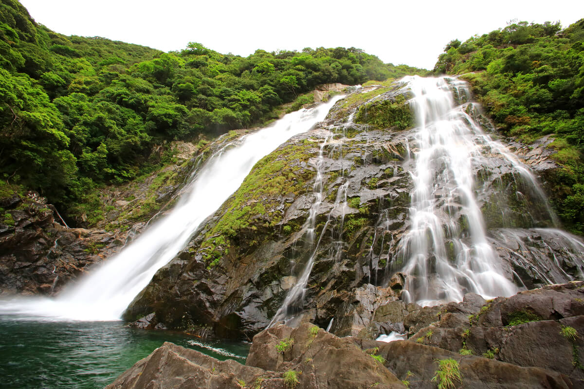
Near the coast, you will find the 88-meter high Oko-no-Taki Falls, one of the most powerful and awe-inspiring waterfalls of Japan. The water cascades in two streams down to an emerald-green plunge pool below and with caution, it is possible to get very close to the falls. The site was selected as one of Japan's 100 best waterfalls and is a must-see for visitors.
In the southwest of Yakushima Island, south of Oko-no-Taki Falls, you will find Tsukasaki Tide Pool. During low tide when the water retreats, a number of tide pools appear in the holes and cracks in the rocks. You will be able to view a colourful marine life including creatures like crabs, sea cucumbers, sea anemones, and little fish.
The island is also home to many animals including Yaku shika (a subspecies of the sika deer), Yakushima zaru (a subspecies of the Japanese macaque) and loggerhead turtles that lay their eggs between May and July at Nagatahama Beach.
Kuchinoerabujima has an area of approximately 38 square kilometres and is located 130 kilometres south of Kagoshima. The island is of volcanic origin and the highest elevations on the island are Mount Furudake with a height of 657 metres and Mount Shindake with a height of 640 metres above sea level. As long as there are no advisory warnings about local volcanic activity, you can hike to the still-active crater of Mount Furudake and see the sulphurous gases rising from vents and fissures, known as fumaroles.
There are many hot springs on Kuchinoerabujima including Yumugi Onsen, Nemachi Onsen, Nishinoyu Onsen and Honmura Onsen. You can first enjoy a good hike and then soak in the warm volcanic spring waters at these spas. South of Yumugi Onsen, you will find Megasaki Tide Pool, a shallow pool that was created by volcanic rock formations and is a host of marine life.
Kuchinoerabujima is also home to the endangered Erabu flying fox, a large nocturnal fruit bat only found here and on the Tokara Islands. The flying foxes have a wingspan of about 80 centimetres and you will be able to see them shortly after sunset in the forest areas of the island where there are many fruits and leaves for them to eat.

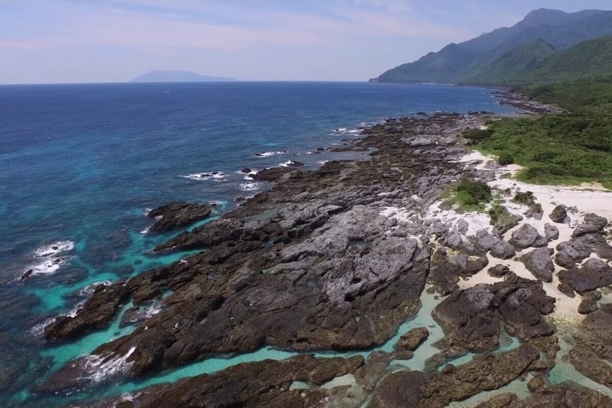
Amami Gunto National Park was established in 2017 in Kagoshima Prefecture and comprises a land area of 42,181 ha and a sea area of 33,082 ha including the following inhabited islands or parts of them: Tokunoshima, Kikaijima, Amami Oshima, Yoronjima, Okinoerabujima, Ukejima, Kakeromajima and Yorojima. The islands can be divided into two types, depending on the way they were formed: high, mountainous islands and low, flat islands. Each island type differs greatly in the varieties of plants, animals, and landscapes that can be seen there.
The high, mountainous islands (Amami Oshima, Kakeromajima, Tokunoshima, Ukejima and Yorojima) are composed of geological formations and were formed before the Neogene Period of the Cenozoic Era. They are characterized by great changes in elevation and mountainous areas that run up to the edge of the coastlines forming extremely steep cliffs leaving little room for flat ground. more
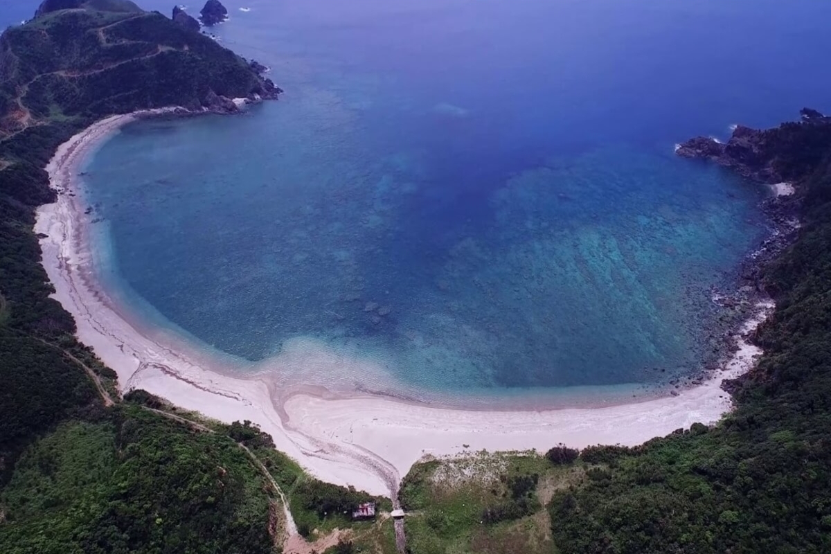
Amami Oshima is the largest island (712.35 km2 in area) in the Satsunan island chain that runs between Kyushu and Okinawa and has a climate, flora and fauna similar to the Okinawa Islands in the south. It attracts visitors during the summer months with its beautiful white sand beaches, warm waters and beautiful coral reef that surround the island. However, the beaches tend to be less crowded than those of Okinawa. The island is of volcanic origin and its highest peak is Mount Yuwanda at 605 metres above sea level. It has a rich human history, unique cuisine and is also known for Oshima Tsumugi silk that has been used for centuries to make high-quality kimono. Rare fauna, including Amami rabbit, Amami jay, habu poisonous snake and green turtle can be found here.
Kakeromajima has an area of 77.39 km2 and is one of the Satsunan Islands running between Kyushu and Okinawa. It is a rugged island southeast of Amami Oshima and its highest point is at 314 metres above sea level. Kakeromajima is surrounded by a coral reef and is separated from Amami Oshima by a narrow strait.
Tokunoshima has an area of 247.77 km2 and is known for having the highest birth rates in Japan, as well as many supercentenarians (people living significantly beyond the age of 100). Mt. Inokawa is known as a treasure of endemic plants including ferns, however the presence of habu snake has kept the rugged areas on the island largely unvisited and relatively untouched.
Ukejima and Yorojima are the smallest inhabited islands in the Amami archipelago, noted for a high population density of habu poisonous snakes.
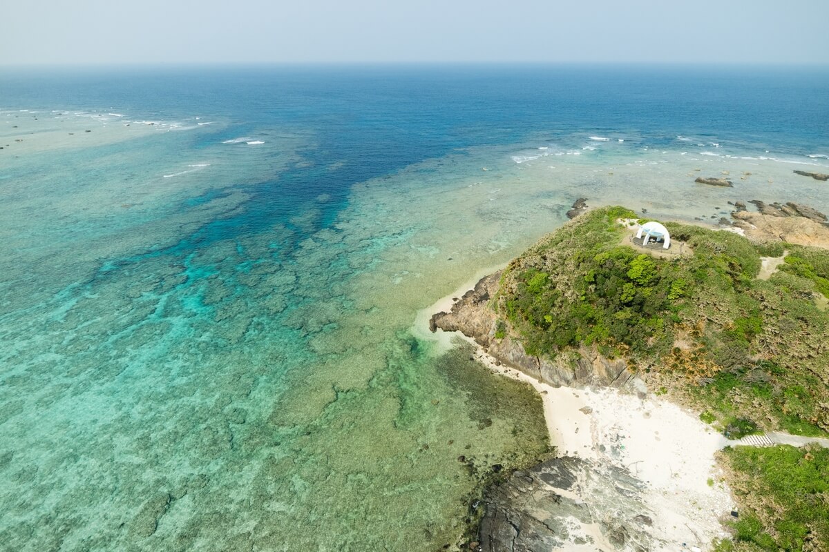
The low, flat islands (Kikaijima, Okinoerabujima and Yoronjima) were formed during the Quaternary Period of the Cenozoic Era from Ryukyu limestone. These islands are low and flat with few mountainous areas, but mostly natural terraced hills. In comparison with the high, mountainous Amami islands mentioned above, there are no habu snakes on Kikaijima, Okinoerabujima and Yoronjima Islands.
Kikaijima has an area of 56.93 km² and is located approximately 25 kilometres east of Amami Oshima. It is a raised coral island with limestone cliffs and draws the attention of geologists as one of the fastest rising coral islands in the world. You can see walls of coral that were built to protect the houses from typhoons. Kikaijima has many beaches, diving spots and is best explored by wandering walks, drives or bicycle excursions along the periphery road.
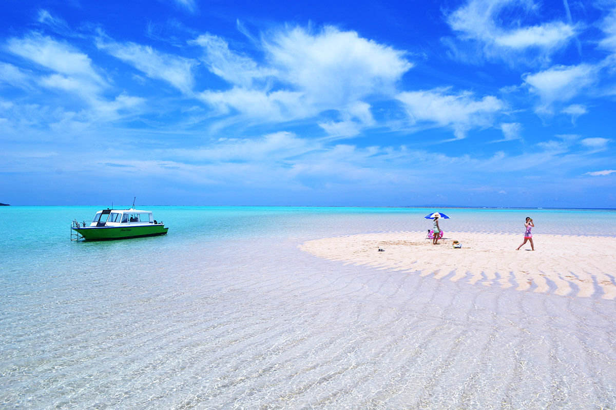
Yoronjima is the southernmost of the Amami Islands located approximately 563 kilometres south of the southern tip of Kyushu. The island has an area of 20.8 km² and is known for its translucently clear waters, white sands and water sports possibilities such as sea kayaking, diving, and swimming.
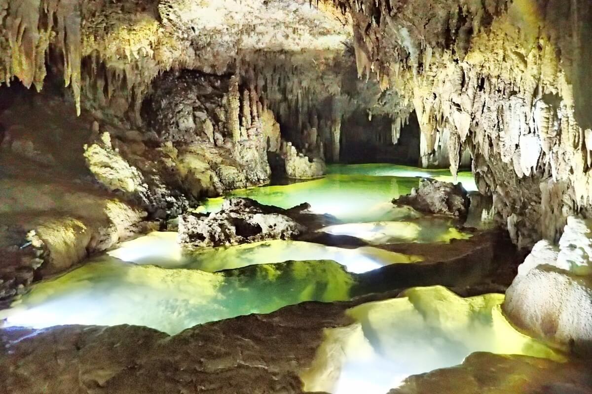
Okinoerabujima has an area of 93.63 km² and is the second southernmost of the Amami Islands. The island is home to over 300 limestone caves including the 3.5 km long Shoryu Cave that is said to be the largest in East Asia. Inside the caves, there are breathtaking stalactite and stalagmite formations. The deep blue waters, the coral reefs and the pristine beaches meet an iconic limestone cave system, a section of which is open to public.
The high, mountainous islands (Amami Oshima, Kakeromajima, Tokunoshima, Ukejima and Yorojima) are composed of geological formations and were formed before the Neogene Period of the Cenozoic Era. They are characterized by great changes in elevation and mountainous areas that run up to the edge of the coastlines forming extremely steep cliffs leaving little room for flat ground. more
Amami Oshima is the largest island (712.35 km2 in area) in the Satsunan island chain that runs between Kyushu and Okinawa and has a climate, flora and fauna similar to the Okinawa Islands in the south. It attracts visitors during the summer months with its beautiful white sand beaches, warm waters and beautiful coral reef that surround the island. However, the beaches tend to be less crowded than those of Okinawa. The island is of volcanic origin and its highest peak is Mount Yuwanda at 605 metres above sea level. It has a rich human history, unique cuisine and is also known for Oshima Tsumugi silk that has been used for centuries to make high-quality kimono. Rare fauna, including Amami rabbit, Amami jay, habu poisonous snake and green turtle can be found here.
Kakeromajima has an area of 77.39 km2 and is one of the Satsunan Islands running between Kyushu and Okinawa. It is a rugged island southeast of Amami Oshima and its highest point is at 314 metres above sea level. Kakeromajima is surrounded by a coral reef and is separated from Amami Oshima by a narrow strait.
Tokunoshima has an area of 247.77 km2 and is known for having the highest birth rates in Japan, as well as many supercentenarians (people living significantly beyond the age of 100). Mt. Inokawa is known as a treasure of endemic plants including ferns, however the presence of habu snake has kept the rugged areas on the island largely unvisited and relatively untouched.
Ukejima and Yorojima are the smallest inhabited islands in the Amami archipelago, noted for a high population density of habu poisonous snakes.
The low, flat islands (Kikaijima, Okinoerabujima and Yoronjima) were formed during the Quaternary Period of the Cenozoic Era from Ryukyu limestone. These islands are low and flat with few mountainous areas, but mostly natural terraced hills. In comparison with the high, mountainous Amami islands mentioned above, there are no habu snakes on Kikaijima, Okinoerabujima and Yoronjima Islands.
Kikaijima has an area of 56.93 km² and is located approximately 25 kilometres east of Amami Oshima. It is a raised coral island with limestone cliffs and draws the attention of geologists as one of the fastest rising coral islands in the world. You can see walls of coral that were built to protect the houses from typhoons. Kikaijima has many beaches, diving spots and is best explored by wandering walks, drives or bicycle excursions along the periphery road.
Yoronjima is the southernmost of the Amami Islands located approximately 563 kilometres south of the southern tip of Kyushu. The island has an area of 20.8 km² and is known for its translucently clear waters, white sands and water sports possibilities such as sea kayaking, diving, and swimming.
Okinoerabujima has an area of 93.63 km² and is the second southernmost of the Amami Islands. The island is home to over 300 limestone caves including the 3.5 km long Shoryu Cave that is said to be the largest in East Asia. Inside the caves, there are breathtaking stalactite and stalagmite formations. The deep blue waters, the coral reefs and the pristine beaches meet an iconic limestone cave system, a section of which is open to public.
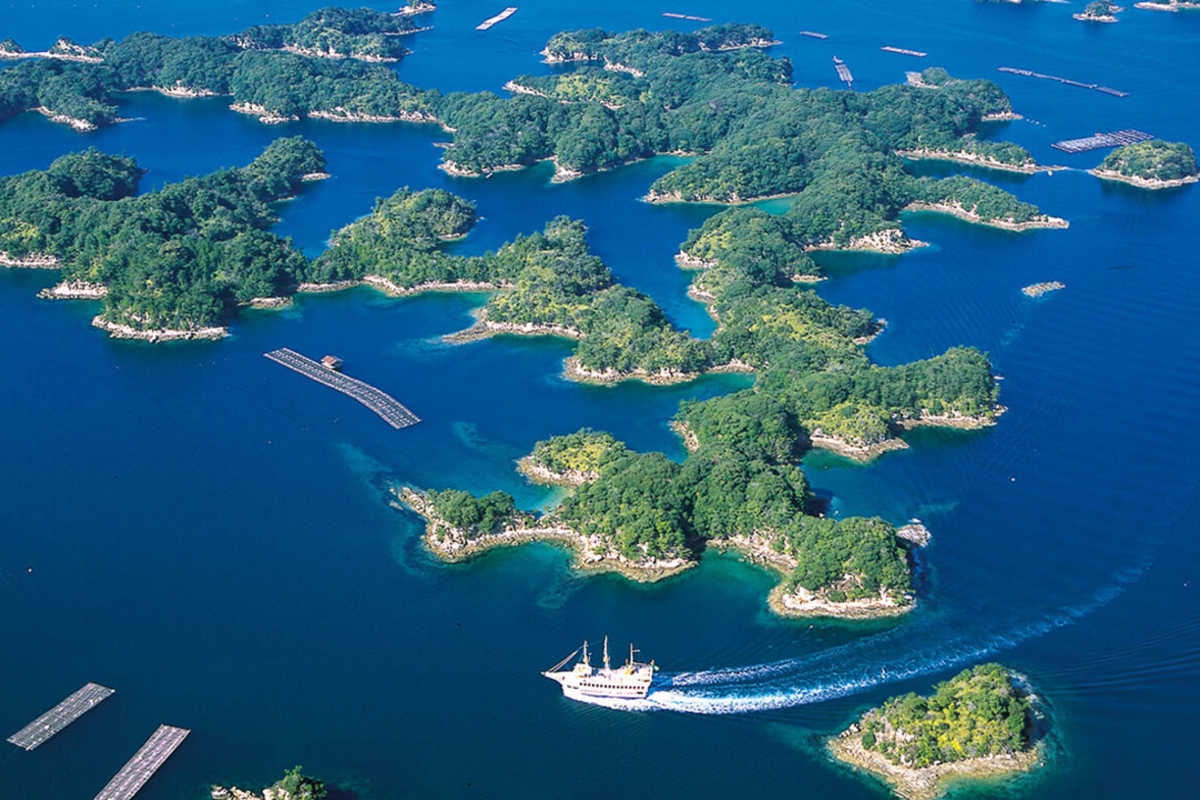

Saikai National Park is situated in northwestern Kyushu and has a land area of 24,646 ha. It was established in 1955 and is noted for its magnificent archipelago seascapes formed from more than 400 large and small islands, including the Kujuku Islands (Kujukushima), Ikitsuki (Ikitsukijima) and Hirado (Hiradojima) Islands and the Goto Islands.
Hirado and Kujuku Islands Area in the north includes the islands of Ikitsuki and Hirado, along with the Kita-Kujuku and Minami-Kujuku island chains. Ikitsuki Island in Hirado area has a well-developed sea cliff especially in the west area and beautiful extensive basalt columnar joints. Hirado Island consists of a variety of volcanic rocks and is noteworthy for its conglomerate stones, the typical eroded volcanic landform which is seen on Mt. more
Hirado and Kujuku Islands Area in the north includes the islands of Ikitsuki and Hirado, along with the Kita-Kujuku and Minami-Kujuku island chains. Ikitsuki Island in Hirado area has a well-developed sea cliff especially in the west area and beautiful extensive basalt columnar joints. Hirado Island consists of a variety of volcanic rocks and is noteworthy for its conglomerate stones, the typical eroded volcanic landform which is seen on Mt. more
Sashidake, Kawachi Pass, Mt. Shijiki, and the lava plateau of Mt. Yasuman.
Kujuku Islands Area has a different geographical feature including dendritic drowned valleys and a seascape of 208 densely scattered islands and inlets from Emukae Bay to Tawaragaura. The inland area on the main island is represented by a low relief hill, while the major mountains of Mt. Eboshi and Mt. Shokan have a lava plateau comprising basalt rocks.
Goto Islands Area comprises the Goto Islands, a chain of seven main islands and many inlets of various sizes in the East China Sea, measuring approximately 90 km in length. Their geographical features were formed by movement and folding during the middle of the Tertiary period with sedimentation, settling, and volcanic activity.
In various parts along the complex coastline, there are tidal flats, which are abundantly populated with rare marine life such as Japanese horseshoe crabs. The park is inhabited by multifarious fauna and serves as a migratory pathway for numerous migrant birds, including the crested honey buzzard (Pernis ptilorhynchus).
Saikai National Park also boasts a diverse environment where the ocean and land meet and is extremely rich flora being populated by seagrass beds, grasslands and secondary broadleaf forest of castanopsis, oak and Camellia japonica. Kanoko-yuri (Lilium speciosum) is a beautiful lily native to southern parts of Japan and China that blooms between mid-July and mid-August in white and pink colours in the park and exudes a rich fragrance.
Yanbaru National Park is a national park in Okinawa Prefecture located on the northern side of Okinawa Main Island on an area of 13,622 ha (land area). It was designated as a national park in 2016 and most of its territory is covered with dense tropical forest, as well as the largest subtropical laurel forest in Japan. The park displays a diverse and varied natural environment including the karst limestone topography with prominent sea cliffs of Cape Hedo (Hedomisaki) in the north, the great clusters of castanopsis, flying spider-monkey tree ferns, chinquapin and machilus thunbergii of Kunigami Village Forest Park and Hiji Waterfall on the western side of the mountainous area and the mangrove forest of Gesashi Bay on the southeastern coast. The park offers you the opportunity to interact with its tremendous natural beauty by driving, more
hiking, canoeing and animal watching.
Cape Hedo is the northernmost point on Okinawa Island and offers amazing views of the seashore scenery and Mt. Hedo, as well as Yoron Island, the southernmost point of Kagoshima Prefecture. You will be able to see the karst limestone formations and the monument that pays tribute to the end of the U.S. occupation of Okinawa.
Kunigami Village Forest Park is an extensive forest park that spreads out at the foot of Mount Yonaha and features a walkway extending for about 3 km. The park offers eco-friendly accommodation to its visitors, with camping, auto-camping and bungalows available. The forest is home to many bird species and you can immerse in this beautiful nature site being woken up by interesting bird songs.
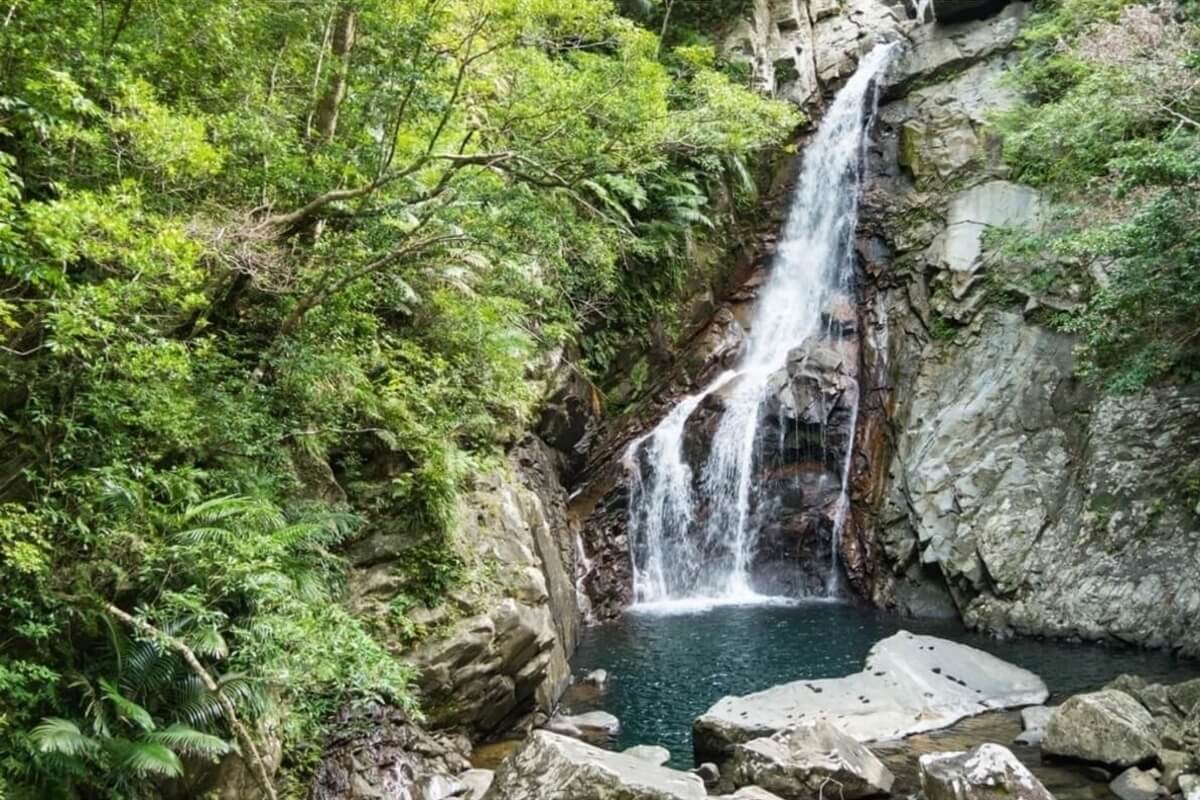
Hiji Waterfall is an impressive 26-metre tall waterfall and can be reached during the 1.5 kilometre hike through the forest, which takes about 40 minutes one way. It is located at the end of the hike offering you a nice spot for rest after experiencing the undisturbed nature of the Yanbaru forests.
Not far from the trailhead to Hiji Waterfall, you will find the Yanbaru Wildlife Conservation Centre that informs the visitors about the local wildlife around the region. The centre was built in 2009 and has ample information and multiple displays focusing on nature protection.
Gesashi Bay Mangrove Forest is the largest mangrove forest on Okinawa Main Island. It has both red and black mangroves and covers an area of over 10 hectares. If you want to observe better the mangrove trees, visit Higashi-son Fureai Hirugi Park, which has an observation tower offering views to the forest and to the ocean. You can enjoy a canoe trip along the calm and shallow Gesashi River that runs through the mangrove forest or opt for a walking trail through the forest, observation points and small museums devoted to the local fauna and flora.
This park is home to many animals endemic to Yanbaru area, including Okinawa rail also known as Yanbaru Kuina (a small, nearly-flightless bird), Okinawa woodpecker, Okinawa robin, Ryukyu long-haired rat, Okinawa spiny rat, Ishikawa’s frog, and Yanbaru long-armed scarab beetle.
Cape Hedo is the northernmost point on Okinawa Island and offers amazing views of the seashore scenery and Mt. Hedo, as well as Yoron Island, the southernmost point of Kagoshima Prefecture. You will be able to see the karst limestone formations and the monument that pays tribute to the end of the U.S. occupation of Okinawa.
Kunigami Village Forest Park is an extensive forest park that spreads out at the foot of Mount Yonaha and features a walkway extending for about 3 km. The park offers eco-friendly accommodation to its visitors, with camping, auto-camping and bungalows available. The forest is home to many bird species and you can immerse in this beautiful nature site being woken up by interesting bird songs.
Hiji Waterfall is an impressive 26-metre tall waterfall and can be reached during the 1.5 kilometre hike through the forest, which takes about 40 minutes one way. It is located at the end of the hike offering you a nice spot for rest after experiencing the undisturbed nature of the Yanbaru forests.
Not far from the trailhead to Hiji Waterfall, you will find the Yanbaru Wildlife Conservation Centre that informs the visitors about the local wildlife around the region. The centre was built in 2009 and has ample information and multiple displays focusing on nature protection.
Gesashi Bay Mangrove Forest is the largest mangrove forest on Okinawa Main Island. It has both red and black mangroves and covers an area of over 10 hectares. If you want to observe better the mangrove trees, visit Higashi-son Fureai Hirugi Park, which has an observation tower offering views to the forest and to the ocean. You can enjoy a canoe trip along the calm and shallow Gesashi River that runs through the mangrove forest or opt for a walking trail through the forest, observation points and small museums devoted to the local fauna and flora.
This park is home to many animals endemic to Yanbaru area, including Okinawa rail also known as Yanbaru Kuina (a small, nearly-flightless bird), Okinawa woodpecker, Okinawa robin, Ryukyu long-haired rat, Okinawa spiny rat, Ishikawa’s frog, and Yanbaru long-armed scarab beetle.


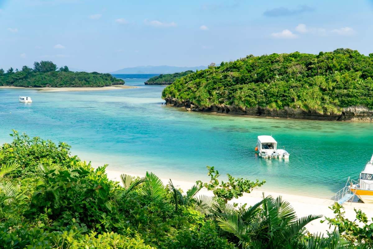
Kerama National Park in Okinawa Prefecture has 3,520 ha of land area and 90,475 hectares of ocean area and comprises the Kerama Islands, a group of islands in the East China Sea, including Tokashiki and Zamami, the two largest islands. The islands, of which only four are inhabited, are located about 40 kilometres west of Okinawa Main Island and were designated a national park in 2014.
The Kerama Islands are a popular side trip due to their pristine, white sand beaches, transparent waters where you can see humpback whales and reefs densely populated by various species of corals. You will be able to enjoy swimming, snorkeling and diving (the best time is from May to October) in the beautiful sea renowned as the “Kerama Blue” that surrounds the Kerama Islands. From January to March, more
The Kerama Islands are a popular side trip due to their pristine, white sand beaches, transparent waters where you can see humpback whales and reefs densely populated by various species of corals. You will be able to enjoy swimming, snorkeling and diving (the best time is from May to October) in the beautiful sea renowned as the “Kerama Blue” that surrounds the Kerama Islands. From January to March, more
the islands become a popular destination for whale watching. The humpback whales come to Kerama Islands to breed and you can see them jumping, blowing, doing head slapping, caudal fin slapping and pectoral fin slapping.
You can access the Kerama Islands via a high-speed vessel from the main land of Okinawa (Tomari Port, Naha city) in about 35 minutes to 50 minutes.
Tokashiki Island (Tokashikijima) is the largest island of the Kerama Islands and has several nice beaches while its interior is mostly covered by forested hills. It offers a few hiking trails through the forested interior and has observation decks from which you can enjoy impressive panoramic views. The highest peak on the island is Mt. Akama standing at 227.3 m above sea level. Near the top of Mt. Akama, you will find the Akamayama Observatory from which you will see some of the uninhabited Kerama Islands including Mae Island and Kuro Island and wide Okinawa Main Island, which is about 30 km away from the observatory.
On the eastern side of the island, of special interest are the Minato no Mieru Oka Observatory, which looks down on Tokashiki village and port and Aran Observatory, located a little further south, which offers views to the rugged east coast and is the only observatory on the island that completes free binoculars so that you could enjoy whale watching here from January to March.
On the western side of the island, you will find Teruyama Observatory, which overlooks the two main beaches: Tokashiku Beach and Aharen Beach. It is located in the middle of the route from Tokashiku Beach to Aharen Beach and offers impressive views of the famous “Kerama Blue” and about 20 islands that belong to the Kerama Islands including Zamami Island, Aka Island and Geruma Island.
Tokashiku Beach is the smaller of the two main beaches on Tokashiki Island and offers opportunities for swimming, sunbathing and snorkelling.
Aharen Beach is the bigger of the two main beaches of the island and is located about 4.5 kilometers south of Tokashiki Port. The white sand beach draws many sunbathers, and the waters are separated into swimming and snorkeling zones. About 10 minutes walk from Aharen Beach is the Kubandaki Observatory with views of the surrounding coastline from a 27-metre hill.
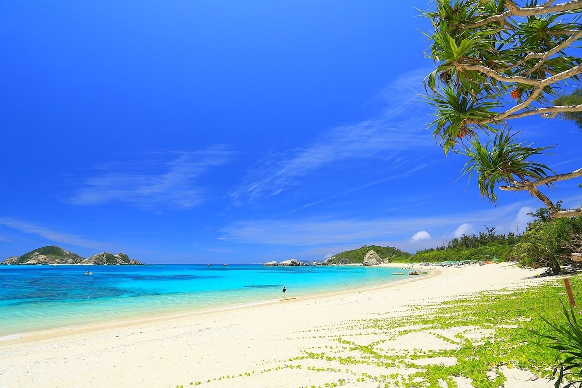
Zamami Island (Zamamijima) is the second largest and the most popular of the Kerama Islands. It is a highly rated beach destination with beautiful white sand and clear waters, which are ideal for swimming, snorkelling and diving. The two main beaches on Zamami, Furuzamami Beach and Ama Beach, are about 20 minutes on foot from the port. Zamami Island can be reached in about 50 minutes from Okinawa Island by a high-speed boat, which is one more reason for its popularity. Not far from Zamami Port are the two small and uninhabited islands of Gahi and Agenashiku that can be reached by a five-minute boat ride.
Located on the southeastern side of the island, Furuzamami Beach is a popular spot and got two stars from the Michelin Green Guide. The white sand of the beach and the “Kerama Blue” known as one of the world’s coral reef areas, which continues for about one kilometre, is a place everyone should see at least once. This place is excellent for snorkelling and swimming during which you can enjoy the clear waters and abundant marine life including tropical fish. The Takatsuki Observatory that stands on the hill above Zamami village offers views of the village and port in one direction and of the tail end of Zamami Island in the other.
Ama Beach is the quieter of the two main beaches and is found on the southwestern side of the island. It faces the two uninhabited islands of Gahi and Agenashiku and offers views of sea turtles swimming in the waters around it. Everyday, they come here to feed from the shallow seagrass meadow. The waters here are relatively shallow and if you want to see coral and tropical fish, you will have to swim or walk further out from the shore. You might spot sea anemones sheltering Red sea clownfish (Amphiprion bicinctus).
The Kerama Islands are located in the subtropical oceanic climate belt and they have ecosystems that are especially unique in Japan. Over 620 species of native plants can be observed on the islands, which are characterized by their ecosystems of great variety. About 46 tree species grow here including the Fan palm and Ryukyu Island pine. The land area is represented by animals and birds including Cervus nippon keramae and its habitat (Yakabijima Island and Gerumajima Island) recognized as a national natural treasure, threatened species such as Ryukyu flying fox, Japanese black-breasted leaf turtle, Ryukyu robin and Spotted ground gecko and rare birds such as Japanese wood pigeon and Common Tern.
The sea area around the Kerama Islands is home to 248 species of reef-building corals in various shapes including table coral, branch coral, horned coral and rock coral. The coral reefs around the Kerama Islands are inhabited by a wide variety of colourful fish including Damselfish, Butterfly fish and the Labroidei.
The waters off the Kerama Islands are a good observation spot for sea turtles such as green turtles and Hawksbill turtles, while the deeper and outer lying sea areas of the Kerama Islands are breeding places for humpback whales.
You can access the Kerama Islands via a high-speed vessel from the main land of Okinawa (Tomari Port, Naha city) in about 35 minutes to 50 minutes.
Tokashiki Island (Tokashikijima) is the largest island of the Kerama Islands and has several nice beaches while its interior is mostly covered by forested hills. It offers a few hiking trails through the forested interior and has observation decks from which you can enjoy impressive panoramic views. The highest peak on the island is Mt. Akama standing at 227.3 m above sea level. Near the top of Mt. Akama, you will find the Akamayama Observatory from which you will see some of the uninhabited Kerama Islands including Mae Island and Kuro Island and wide Okinawa Main Island, which is about 30 km away from the observatory.
On the eastern side of the island, of special interest are the Minato no Mieru Oka Observatory, which looks down on Tokashiki village and port and Aran Observatory, located a little further south, which offers views to the rugged east coast and is the only observatory on the island that completes free binoculars so that you could enjoy whale watching here from January to March.
On the western side of the island, you will find Teruyama Observatory, which overlooks the two main beaches: Tokashiku Beach and Aharen Beach. It is located in the middle of the route from Tokashiku Beach to Aharen Beach and offers impressive views of the famous “Kerama Blue” and about 20 islands that belong to the Kerama Islands including Zamami Island, Aka Island and Geruma Island.
Tokashiku Beach is the smaller of the two main beaches on Tokashiki Island and offers opportunities for swimming, sunbathing and snorkelling.
Aharen Beach is the bigger of the two main beaches of the island and is located about 4.5 kilometers south of Tokashiki Port. The white sand beach draws many sunbathers, and the waters are separated into swimming and snorkeling zones. About 10 minutes walk from Aharen Beach is the Kubandaki Observatory with views of the surrounding coastline from a 27-metre hill.
Zamami Island (Zamamijima) is the second largest and the most popular of the Kerama Islands. It is a highly rated beach destination with beautiful white sand and clear waters, which are ideal for swimming, snorkelling and diving. The two main beaches on Zamami, Furuzamami Beach and Ama Beach, are about 20 minutes on foot from the port. Zamami Island can be reached in about 50 minutes from Okinawa Island by a high-speed boat, which is one more reason for its popularity. Not far from Zamami Port are the two small and uninhabited islands of Gahi and Agenashiku that can be reached by a five-minute boat ride.
Located on the southeastern side of the island, Furuzamami Beach is a popular spot and got two stars from the Michelin Green Guide. The white sand of the beach and the “Kerama Blue” known as one of the world’s coral reef areas, which continues for about one kilometre, is a place everyone should see at least once. This place is excellent for snorkelling and swimming during which you can enjoy the clear waters and abundant marine life including tropical fish. The Takatsuki Observatory that stands on the hill above Zamami village offers views of the village and port in one direction and of the tail end of Zamami Island in the other.
Ama Beach is the quieter of the two main beaches and is found on the southwestern side of the island. It faces the two uninhabited islands of Gahi and Agenashiku and offers views of sea turtles swimming in the waters around it. Everyday, they come here to feed from the shallow seagrass meadow. The waters here are relatively shallow and if you want to see coral and tropical fish, you will have to swim or walk further out from the shore. You might spot sea anemones sheltering Red sea clownfish (Amphiprion bicinctus).
The Kerama Islands are located in the subtropical oceanic climate belt and they have ecosystems that are especially unique in Japan. Over 620 species of native plants can be observed on the islands, which are characterized by their ecosystems of great variety. About 46 tree species grow here including the Fan palm and Ryukyu Island pine. The land area is represented by animals and birds including Cervus nippon keramae and its habitat (Yakabijima Island and Gerumajima Island) recognized as a national natural treasure, threatened species such as Ryukyu flying fox, Japanese black-breasted leaf turtle, Ryukyu robin and Spotted ground gecko and rare birds such as Japanese wood pigeon and Common Tern.
The sea area around the Kerama Islands is home to 248 species of reef-building corals in various shapes including table coral, branch coral, horned coral and rock coral. The coral reefs around the Kerama Islands are inhabited by a wide variety of colourful fish including Damselfish, Butterfly fish and the Labroidei.
The waters off the Kerama Islands are a good observation spot for sea turtles such as green turtles and Hawksbill turtles, while the deeper and outer lying sea areas of the Kerama Islands are breeding places for humpback whales.

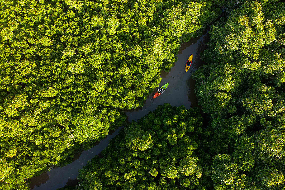
Iriomote-Ishigaki National Park in Okinawa Prefecture is the southernmost national park in Japan and has a land area of 21.958 ha. It was designated a national park in 1972 and since 2007 incorporates parts of the nearby Ishigaki Island and the surrounding sea. The park is characterized by a natural landscape typical of the subtropical zone including the largest mangrove forest in Japan that stretches out beside the Nakama River on Iriomote Island, subtropical broadleaf evergreen forests of Castanopsis sieboldii and Quercus miyagii, coastal forests of Pandanus odorifer and Beach hibiscus, as well as coral reefs. You can enjoy high-quality nature experiences in the park, such as canoeing, snorkelling, bird and animal watching, diving, trekking and driving.
Iriomote Island (Iriomotejima) is the second largest island of Okinawa and a popular destination for swimming, more
Iriomote Island (Iriomotejima) is the second largest island of Okinawa and a popular destination for swimming, more
snorkelling, scuba diving, river kayaking, sailing, hiking, etc. Jungle and mangrove boat cruises are organized on the two longest rivers of the island: the Urauchi River (Urauchigawa) and the Nakama River (Nakamagawa), while guided kayaking tours operate on those, as well as on many of the smaller rivers around the island. The beaches offer swimming, snorkelling and diving opportunities. Scuba diving is especially interesting at Manta Way, the strait between Iriomote and nearby Kohama Island, where schools of manta rays congregate in spring and summer.
Ishigaki Island (Ishigakijima) is the main island of the Yaeyama Islands and offers several nice beaches and good snorkelling and diving activities in the surrounding coral reefs. Snorkelling can be enjoyed at nearly every beach on the island, while diving is especially captivating around Manta Scramble near Kabira Bay where the famous manta rays congregate in large numbers in summer and early autumn.
Kabira Bay provides spectacular views of the deep blue ocean, white beaches and islets dotting the ocean and was awarded three stars by the Michelin Green Guide. The beautiful underwater seascape can be enjoyed from glass-bottom boats allowing you to see the beautiful ocean life. Ishigaki also has the highest mountain in Okinawa Prefecture, Mt. Omoto, which can be climbed in about one hour. Its highest peak, which is at 525.5 metres above sea level, offers a stunning view of Omoto Mountain Range, as well as the beautiful ocean and coral reefs surrounding Ishigakijima.
The park is home to endemic plant species that only grow on Iriomote and Ishigaki Islands, such as Yaeyama palm tree and Rhododendron amanoi Ohwi, as well as Rhaphidophora kortharthii and jewel orchid (Macodes petola). Species such as Asarum yaeyamensis and Chikusichloa brachyanthera only grow on Iriomote Island.
Iriomote-Ishigaki National Park is also home to many rare species of animals and birds including Iriomote wildcat (only found on Iriomote Island), Kishinoue’s giant skink (endemic to the southern Ryukyu Islands), Sakishima grass lizard (endemic to Ishigaki Island), Crested serpent eagle and Yellow-margined box turtle.
Between Ishigaki and Iriomote Islands lies Sekisei Lagoon, the largest coral reef area of Japan and a snorkelling paradise. The area has the largest diversity of coral reef species in Japan due to influence of the Kuroshio Current, whose warm waters sustain the coral reefs. More than 360 species of hermatypic coral (Scleractinia) have been confirmed here.