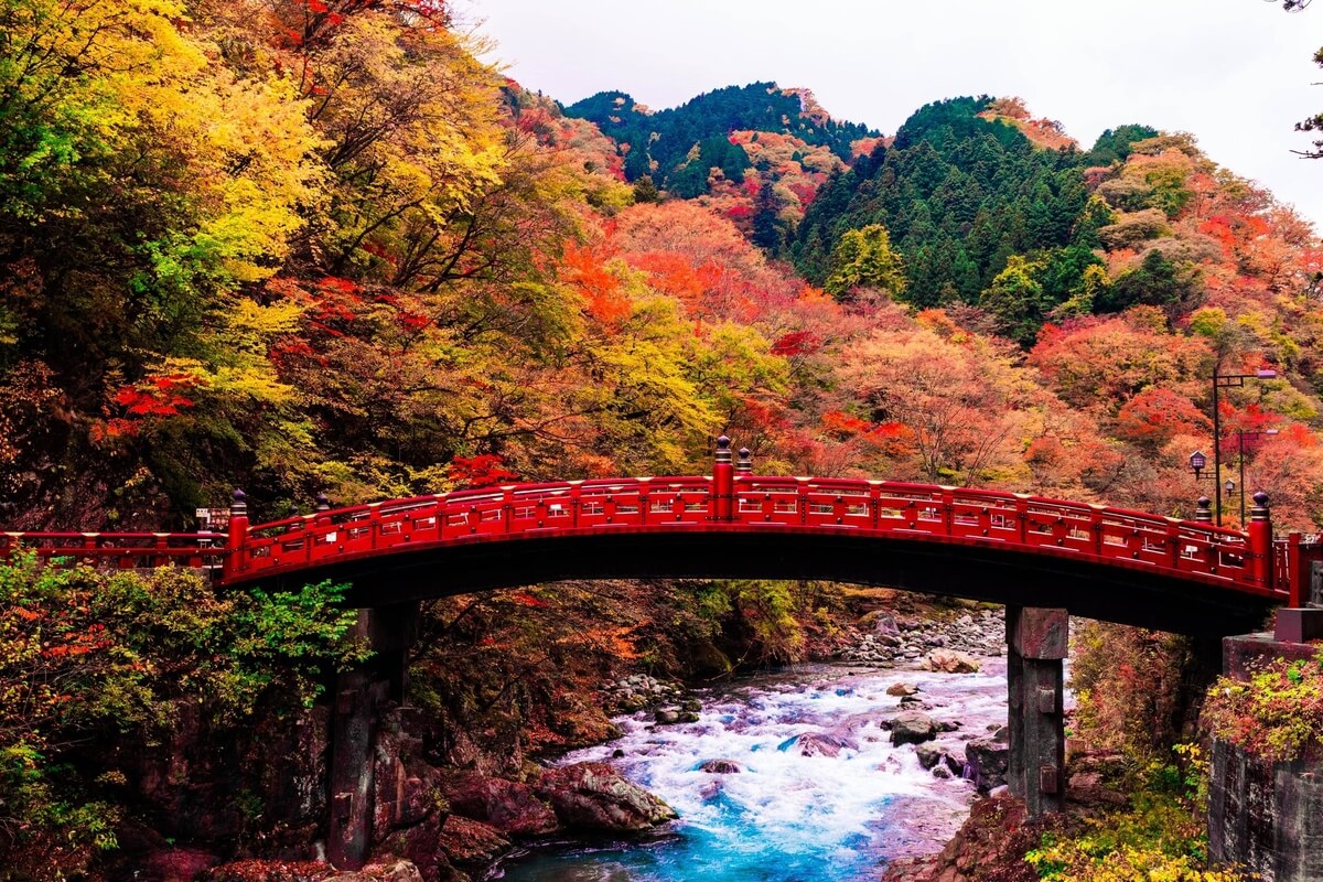
Both a UNESCO World Heritage Site and a national park, Nikko includes a large variety of natural and cultural attractions such as the Toshogu Shrine - Japan’s most lavishly decorated shrine and the mausoleum of Tokugawa Ieyasu, Kinugawa Onsen, Nasu-Shiobara, and the lakes, mountains and waterfalls of Okunikko.
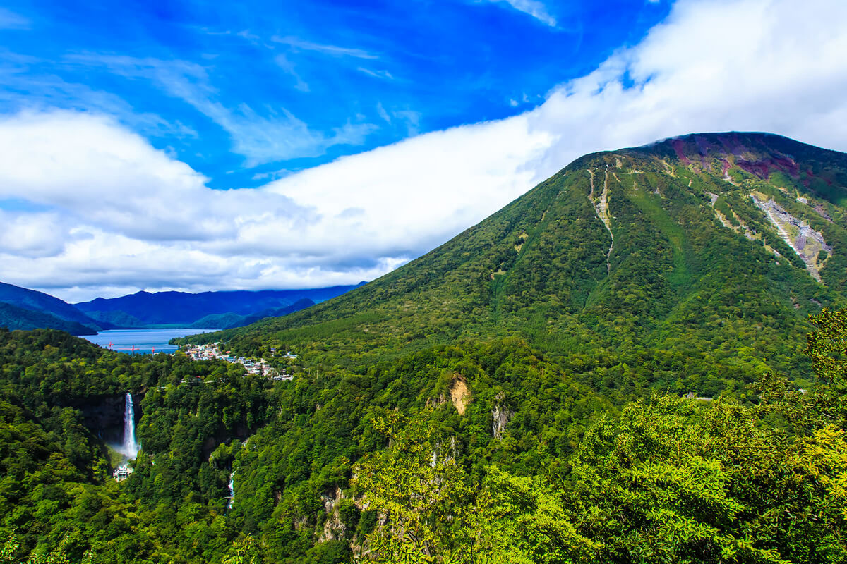
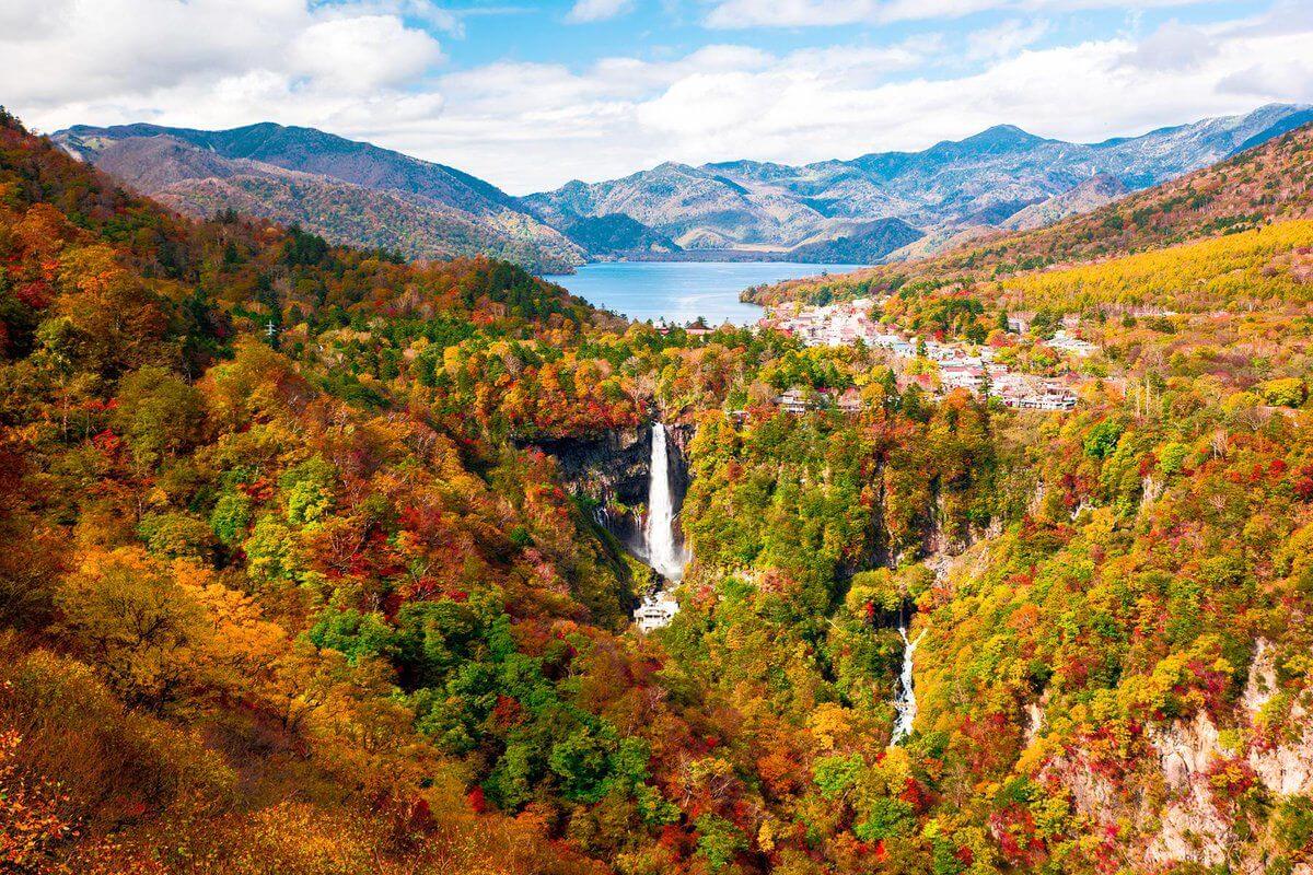
Nikko National Park opened in 1934 and is one of the first national parks in Japan. The total area of the park is 114,908 ha and most of it is mountainous. The area is dominated by the Nasu Volcanic Belt including such mountains as Mt. Shirane (2,578 m above sea level), Mt. Nantai (2,486 m above sea level), and Mt. Nasudake (1,917 m above sea level), which is still an active volcano. These mountains are extremely beautiful in autumn when the wide plateaus at their bases and the additional beauty of lakes, more
Nikko National Park opened in 1934 and is one of the first national parks in Japan. The total area of the park is 114,908 ha and most of it is mountainous. The area is dominated by the Nasu Volcanic Belt including such mountains as Mt. Shirane (2,578 m above sea level), Mt. Nantai (2,486 m above sea level), and Mt. Nasudake (1,917 m above sea level), which is still an active volcano. These mountains are extremely beautiful in autumn when the wide plateaus at their bases and the additional beauty of lakes, more
reservoirs, magnificent falls, and valleys with splendid autumn leaves will offer you splendid views.
Nasukashi and Shiobara areas have volcanic mountains including Mt. Chausu that is still fuming and large plateaus. Rich forests cover this area from the mountain bases to the hillsides, and as the elevation increases, the landscape changes from broadleaf deciduous forests of Japanese beech and oak trees at the foot of the mountain to coniferous forests mainly of fir and Thuja trees on the upper areas. Because of the cold climate and volcanic soil among other factors, on the ridgelines along the peaks of Mt. Nasudake, you can observe alpine vegetation, such as creeping pine trees.
Many animals also seen on Japan’s main island can be found here including large mammals like the Japanese serows, Japanese sika deer, and Asian black bear, as well as valley fish and amphibian species including Buerger’s Frog.
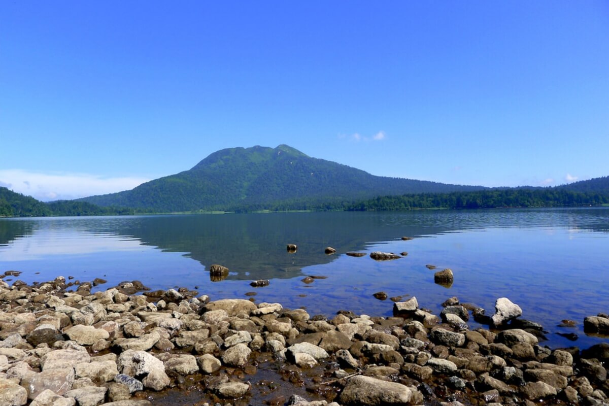
Nikko/Kinugawa/Kuriyama areas have stratovolcanoes of Mt. Nantai, Mt. Nyoho and Mt. Akanagi, and many lava domes and small volcanoes, which are collectively called the Nikko volcanic group. Many lakes, reservoirs, wetlands, and falls created by the effect of volcanic activities can be seen at the bases and hillsides of the Nikko volcanic group. The deciduous broadleaf forest zone of mainly Japanese beech and oak with some maple trees that can be found at the foot of the mountains shows stunning coloured-leaf scenes in autumn. The upper areas with altitudes of about 1,600 m are mostly covered by coniferous forests, while in the higher places Erman’s birch trees grow. The ridgelines and summits, above the altitude of about 2,400 m are characterized by shrubby, herbaceous alpine-belt vegetation. As for animals, large and small mammals including Japanese sika deer and Japanese macaque inhabit the area.
There are many historical buildings and sites especially in and around the Nikko city area, such as the Toshogu Shrine, Futarasan jinja Shrine, and Rinnoji Temple, forming the Shrines and Temples of Nikko, a World Heritage Site. Therefore, at Nikko National Park the visitors can experience a beautiful fusion of nature, history, and culture by visiting a number of historic world-heritage temples and shrines and the natural scenery surrounding them.
Nasukashi and Shiobara areas have volcanic mountains including Mt. Chausu that is still fuming and large plateaus. Rich forests cover this area from the mountain bases to the hillsides, and as the elevation increases, the landscape changes from broadleaf deciduous forests of Japanese beech and oak trees at the foot of the mountain to coniferous forests mainly of fir and Thuja trees on the upper areas. Because of the cold climate and volcanic soil among other factors, on the ridgelines along the peaks of Mt. Nasudake, you can observe alpine vegetation, such as creeping pine trees.
Many animals also seen on Japan’s main island can be found here including large mammals like the Japanese serows, Japanese sika deer, and Asian black bear, as well as valley fish and amphibian species including Buerger’s Frog.
Nikko/Kinugawa/Kuriyama areas have stratovolcanoes of Mt. Nantai, Mt. Nyoho and Mt. Akanagi, and many lava domes and small volcanoes, which are collectively called the Nikko volcanic group. Many lakes, reservoirs, wetlands, and falls created by the effect of volcanic activities can be seen at the bases and hillsides of the Nikko volcanic group. The deciduous broadleaf forest zone of mainly Japanese beech and oak with some maple trees that can be found at the foot of the mountains shows stunning coloured-leaf scenes in autumn. The upper areas with altitudes of about 1,600 m are mostly covered by coniferous forests, while in the higher places Erman’s birch trees grow. The ridgelines and summits, above the altitude of about 2,400 m are characterized by shrubby, herbaceous alpine-belt vegetation. As for animals, large and small mammals including Japanese sika deer and Japanese macaque inhabit the area.
There are many historical buildings and sites especially in and around the Nikko city area, such as the Toshogu Shrine, Futarasan jinja Shrine, and Rinnoji Temple, forming the Shrines and Temples of Nikko, a World Heritage Site. Therefore, at Nikko National Park the visitors can experience a beautiful fusion of nature, history, and culture by visiting a number of historic world-heritage temples and shrines and the natural scenery surrounding them.
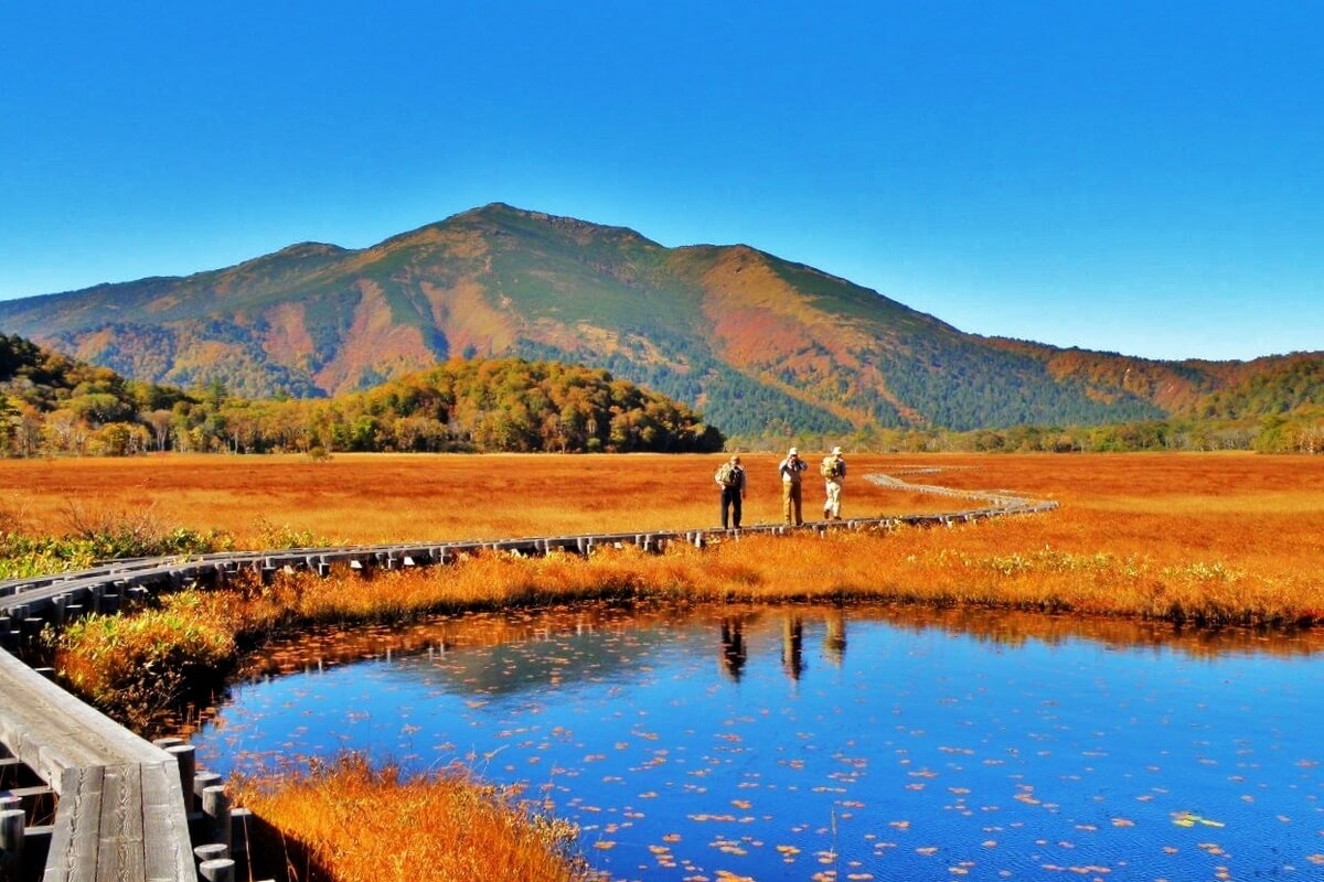
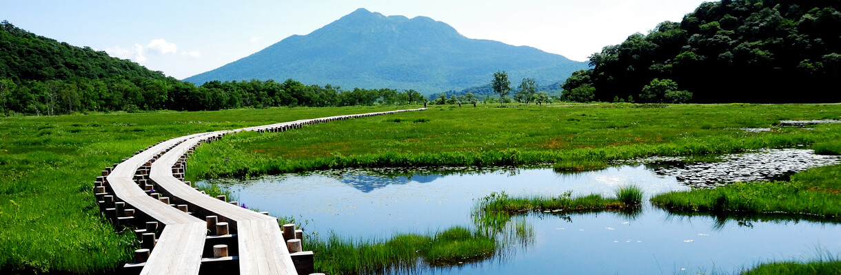
Oze National Park is located about 150 km north of Tokyo and centres around a large marshland at an altitude of 1,400 metres - Ozegahara Marshland that together with Ozenuma Pond constitute the most known features of the park. It is very popular from late spring to early summer during the blooming of skunk cabbages and as a place to see early autumn colours, whereas in the winter it is covered by deep snow.
From 1934 until 2007 most of Oze National Park was part of the nearby Nikko National Park. In 2007, the Oze Area was separated from Nikko National Park and a few nearby mountains including Mt. Aizu-Komagatake, Mt. Tashiro, and Mt. Taishaku were added to the park grounds.
Oze Area is characterized by a mountainous region formed through the eruptions of the Oze volcanoes. more
Because of the volcanic eruptions, volcanic high moors such as Lake Ozenuma and Ozegahara Plateau areas formed. Ozegahara Plateau comprises Honshu’s largest (approx. 760 ha) mountain marsh - Ozegahara Marshland, that is about 6 km long and 1 km wide, and has hundreds of small, distinct pools. The marshland offers possibilities for walking and hiking. The most popular among the trailheads is the Hatomachitoge trailhead (only one-hour walk from the western end of the marshlands). Following the trail from the eastern end of Ozegahara Marshland in about an hour and a half, you can reach Ozenuma Pond, the second most famous feature of the park. There is also a 6 km path around the entire pond that sometimes goes through the water and sometimes through the forest. In late May and early June, all across Ozegahara, you can see the beautiful landscape of the white skunk cabbages in bloom. The marshland is also very attractive in late July and early August when the yellow alpine lilies are in bloom.
A number of non-volcanic peaks surround Oze, each with an altitude of around 2,000 m, including Mt. Aizu-Komagatake to the north and Mt. Taishaku and Mt. Tashiro to the east. In comparison with the mountains in the Oze Area, these ones are relatively gentle-looking mountains, and many marshes and ponds can be seen along their ridgelines.
The national park has a diversity of fauna with many large mammals including the Japanese serow and Asian black bear, which prefer rich forest environments. There is also a rich variety of birds and insect species and all 17 of Japan’s native northern dragonfly species have been confirmed as living in the park.
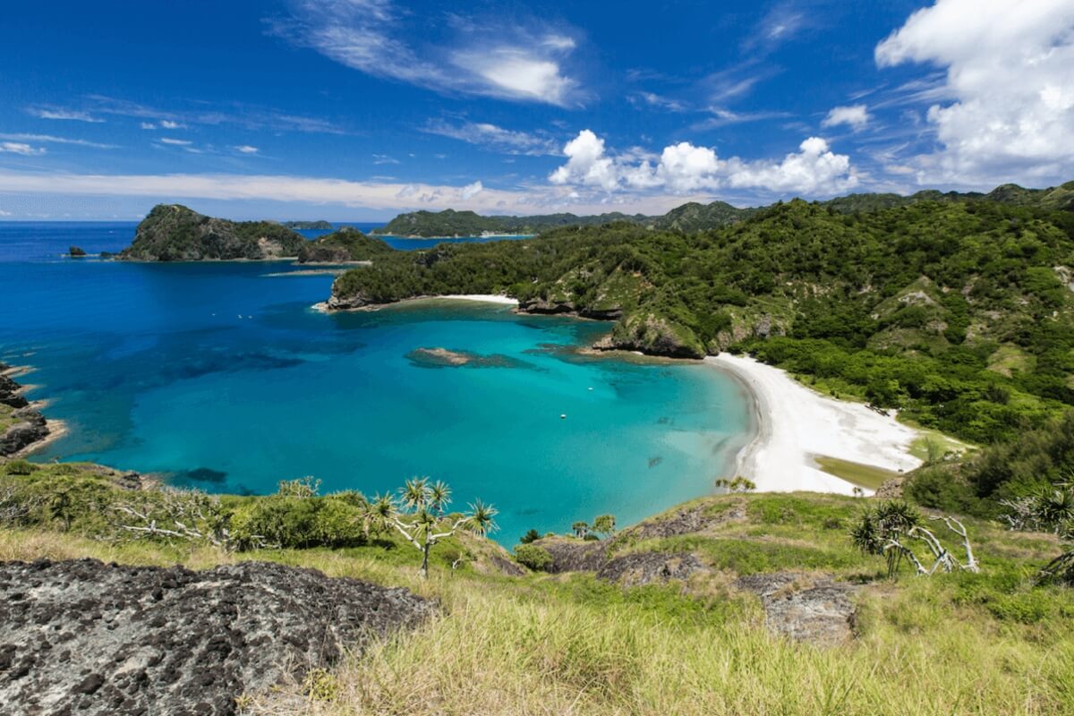
Ogasawara National Park has an area of 6,629 ha (land area) and was designated as a national park in 1972. Later, in June 2011, it was registered as a World Heritage Site. The park consists of the subtropical Ogasawara Islands, which are a remote island chain located 1,000 km south of the Japanese archipelago. Due to the fact that they are oceanic islands that have never been connected to the mainland and thus have unique habitats and endemic plants and animals found only on them.
Consisting of 30 islands located on a similar latitude as Okinawa, the Ogasawara Islands offer a subtropical climate with warm temperatures all year around and activities such as whale and dolphin watching, sea kayaking, hiking, snorkelling and diving. The islands offer landscapes unique to subtropical oceanic islands, more
Consisting of 30 islands located on a similar latitude as Okinawa, the Ogasawara Islands offer a subtropical climate with warm temperatures all year around and activities such as whale and dolphin watching, sea kayaking, hiking, snorkelling and diving. The islands offer landscapes unique to subtropical oceanic islands, more
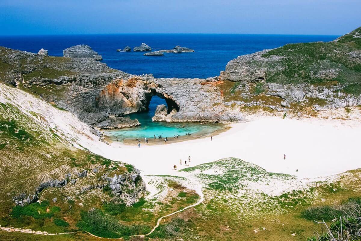
pillow lava, and unique coastal landforms. The underwater habitat consists of marine mammals including humpback whales and dolphins, green turtles, coral reefs, and tropical fish. The islands are also home to over 190 endangered avian species such as the Bonin flying fox and over 400 native plant species.
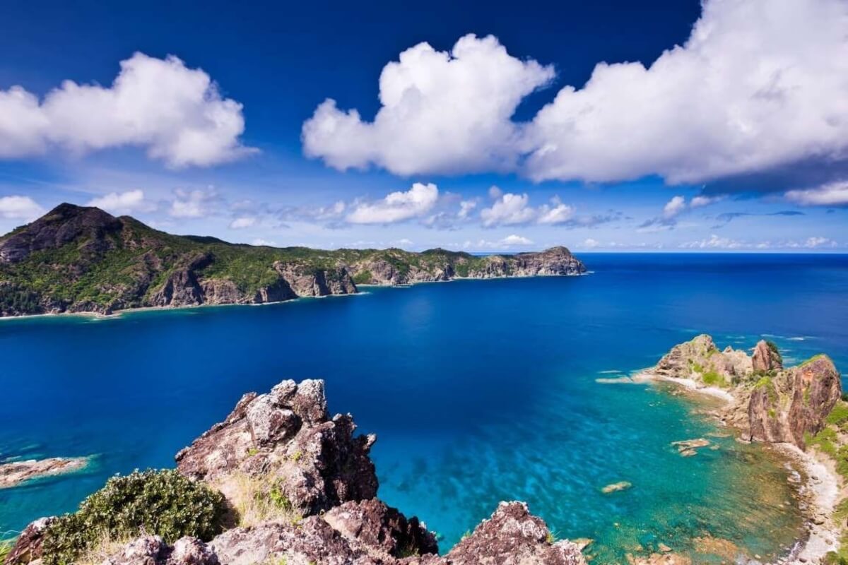
It is important to mention that only the two largest islands, Chichijima (Father Island) and Hahajima (Mother Island) are inhabited. Visitors can see piles of pillow lava that formed after magma solidified during past submarine volcanic activity. On Chichijima Island you can see a forest of short trees called a dry scrub forest where endemic species that evolved by changing the shape of leaves in the dry climate of the Chichijima Island can be found. On the other hand, a wide distribution of tall trees that prefer high humidity and rain, called a hydrarch tall tree forest can be seen on Hahajima Island.
You can reach Chichijima Island by taking the 25-hour cruise on the Ogasawara-maru Liner to Futami Port on Chichijima Island from the Takeshiba Passenger Ship Terminal in Tokyo. The ocean ferry is equipped with hotel-like cabins, a snack bar on the deck where you can enjoy the views of the Pacific Ocean, and a restaurant serving dishes made with specialty products of Ogasawara.