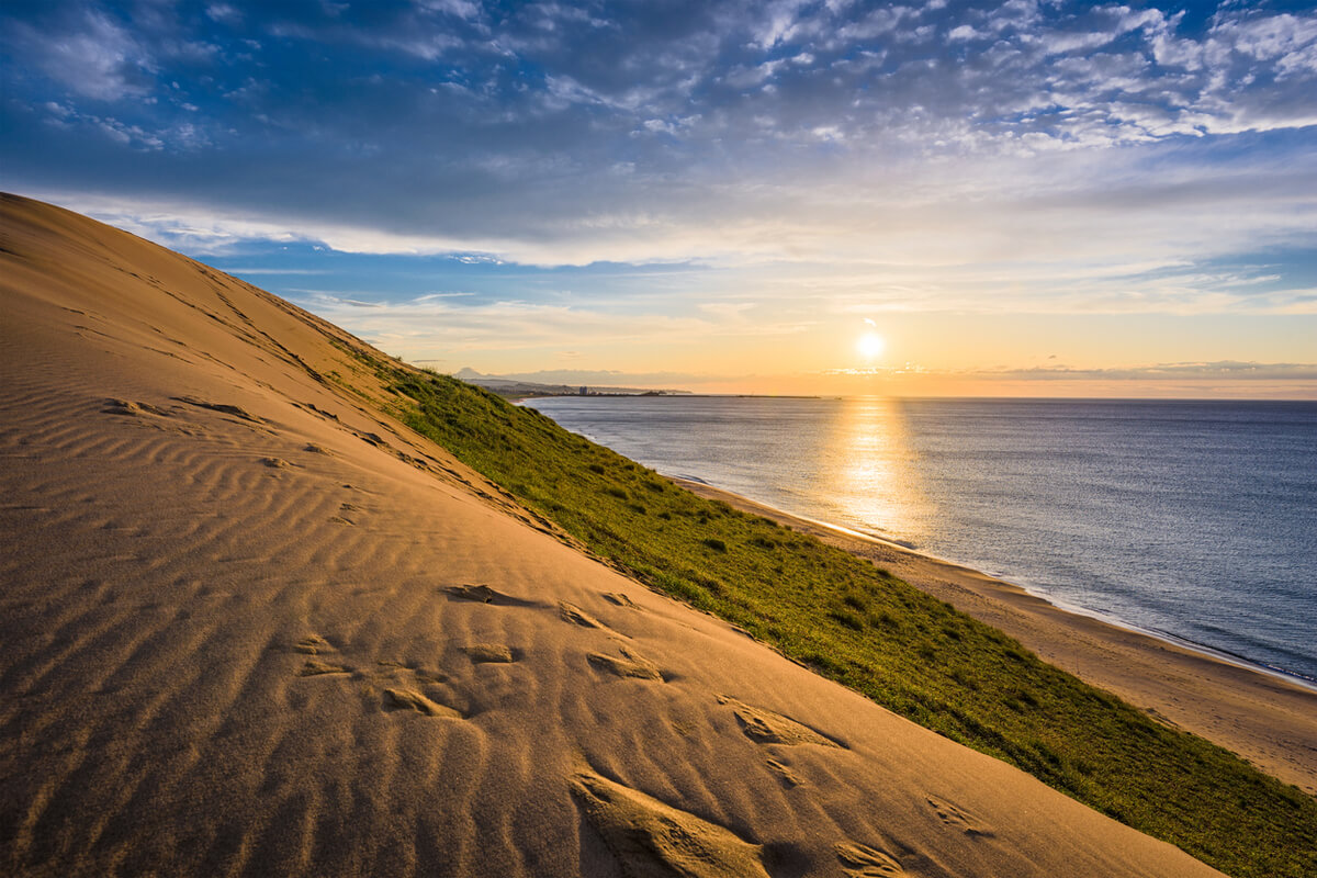
Established in 1963, Sanin Kaigan National Park stretches along the Sea of Japan coast from Tottori to Kyotango in Tottori Prefecture of Chugoku region and Hyogo and Kyoto Prefectures of Kansai region of Japan. It covers an area of 8,783 ha (land area) and includes beautiful rocky shoreline, many inlets, rock formations, islands, caves and the Tottori Sand Dunes, the largest in Japan measuring 16 km east-west and 2.4 km north-south. Due to these diverse landforms, the park is also referred to as a “Geological Park”.
The Tottori Sand Dunes were formed through wave erosion and by sand flowing down from the Chugoku Mountains, carried by rivers and ocean winds. more
The Tottori Sand Dunes were formed through wave erosion and by sand flowing down from the Chugoku Mountains, carried by rivers and ocean winds. more
The sand and wind created beautiful patterns and depressions forming a unique, richly varying and undulating topography.
On the southern side of the Tottori Sand Dunes, Tanegaike Pond is located. It is a natural pond with a circumference of approx. 3.4 km and a surface area of approx. 0.23 square kilometres. The pond was formed by the sedimentation of sand from the dune and a nearby river and its maximum depth is about 17 m.
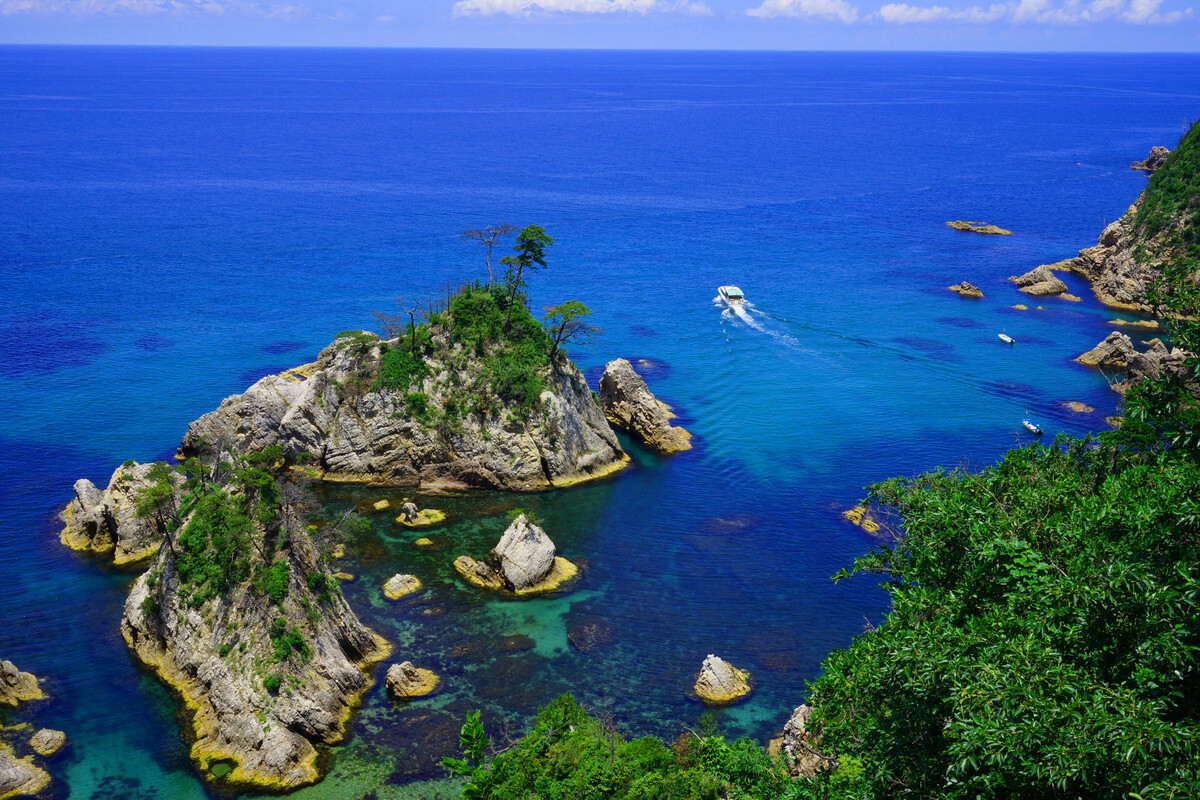
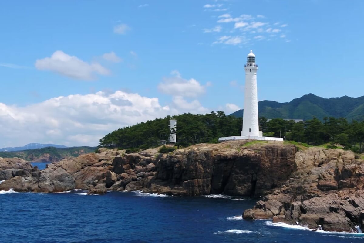
Near the Tottori Sand Dunes, there is also a place named the Uradome Beach, where the sea has a transparency zone of 25 metres and the land area consists of white sand and green pine, considered one of the most spectacular sights of Japan. The rocky shoreline measures 15 km in length and precipitous cliffs, large and small pine-covered islands and promontories surround it.
In the ocean, north of Ajiro Port there is a small granite island - Sengan Matsushima Island, one of the symbols of the Uradome Coast. The island has a circumference of 50 m and a height of 10 m and a tunnel with a depth of 20 m can be seen in the centre of it. A splendid pine tree stands on its summit.
The Yoroinosode are huge 65 m high and 200 m long cliffs located in the western part of the Kasumi Beach that were formed about 3 million years ago.
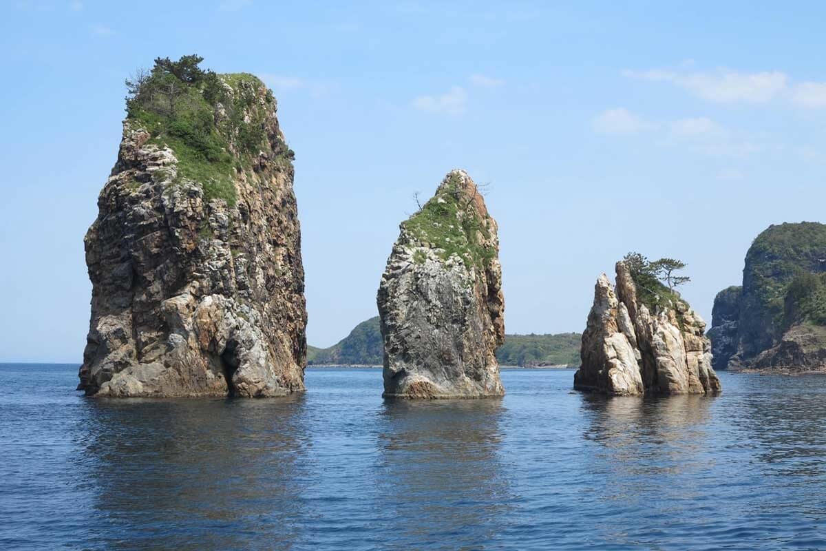
Hasakari-iwa Rock is a strange-shaped rock located on the shoreline of the Takeno Beach. It looks as if a round rock has been wedged between the other two outcropping rocks, but in fact these three rocks used to form one large rock. The site represents a place of scenic beauty.
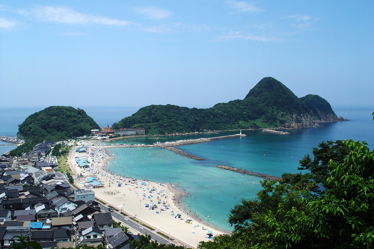
The Nekozaki Peninsula found near Takeno Beach, looks like a crouching cat when viewed from the inland. Originally it was an island, but the sand and gravel carried by rivers built up and connected the island and the mainland, thus on the eastern side of the peninsula there is a sandy beach (Takeno Beach). There is a hiking and nature trail that is easy to follow, however proper shoes are obligatory, as there are some steep inclines, declines, potholes carved by waves and stairs along the way.
Genbudo Cave was formed by volcanic activity 1.6 million years ago when a volcanic explosion occurred and caused magma to leak and cool down. It is possible to view the cave’s beautiful lines that came up when Genbu rocks were washed by waves. In Genbudo Cave Park, there is also a Genbu Cave Museum, where mineral crystals, minerals, and fossils are displayed.
Kumihama Bay is a lagoon separated from the Sea of Japan with a sand bank measuring approx. 28 km in length. Inside the calm inland sea, there is an oyster farm and the tender “Kumihama Oyster” is famous in the local area.
Around Kumihama the visitors can enjoy the beautiful landscape of Mt. Kabuto, a cone-shaped peak with an altitude of 191 m that lies on the southeastern side of Kumihama Bay. The mountain has a long history as an object of worship and there is a Kumano-jinja Shrine at the summit.
On the southern side of the Tottori Sand Dunes, Tanegaike Pond is located. It is a natural pond with a circumference of approx. 3.4 km and a surface area of approx. 0.23 square kilometres. The pond was formed by the sedimentation of sand from the dune and a nearby river and its maximum depth is about 17 m.
Near the Tottori Sand Dunes, there is also a place named the Uradome Beach, where the sea has a transparency zone of 25 metres and the land area consists of white sand and green pine, considered one of the most spectacular sights of Japan. The rocky shoreline measures 15 km in length and precipitous cliffs, large and small pine-covered islands and promontories surround it.
In the ocean, north of Ajiro Port there is a small granite island - Sengan Matsushima Island, one of the symbols of the Uradome Coast. The island has a circumference of 50 m and a height of 10 m and a tunnel with a depth of 20 m can be seen in the centre of it. A splendid pine tree stands on its summit.
The Yoroinosode are huge 65 m high and 200 m long cliffs located in the western part of the Kasumi Beach that were formed about 3 million years ago.
Hasakari-iwa Rock is a strange-shaped rock located on the shoreline of the Takeno Beach. It looks as if a round rock has been wedged between the other two outcropping rocks, but in fact these three rocks used to form one large rock. The site represents a place of scenic beauty.
The Nekozaki Peninsula found near Takeno Beach, looks like a crouching cat when viewed from the inland. Originally it was an island, but the sand and gravel carried by rivers built up and connected the island and the mainland, thus on the eastern side of the peninsula there is a sandy beach (Takeno Beach). There is a hiking and nature trail that is easy to follow, however proper shoes are obligatory, as there are some steep inclines, declines, potholes carved by waves and stairs along the way.
Genbudo Cave was formed by volcanic activity 1.6 million years ago when a volcanic explosion occurred and caused magma to leak and cool down. It is possible to view the cave’s beautiful lines that came up when Genbu rocks were washed by waves. In Genbudo Cave Park, there is also a Genbu Cave Museum, where mineral crystals, minerals, and fossils are displayed.
Kumihama Bay is a lagoon separated from the Sea of Japan with a sand bank measuring approx. 28 km in length. Inside the calm inland sea, there is an oyster farm and the tender “Kumihama Oyster” is famous in the local area.
Around Kumihama the visitors can enjoy the beautiful landscape of Mt. Kabuto, a cone-shaped peak with an altitude of 191 m that lies on the southeastern side of Kumihama Bay. The mountain has a long history as an object of worship and there is a Kumano-jinja Shrine at the summit.
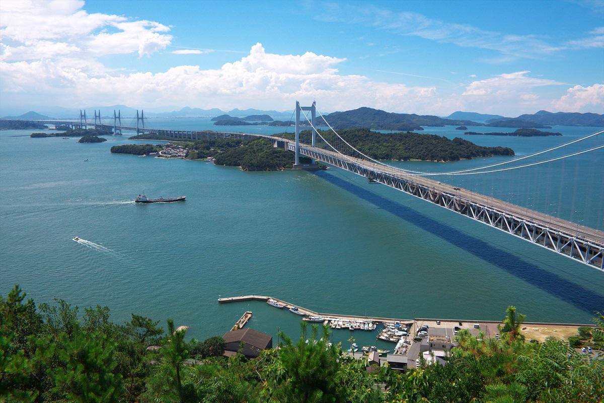
Setonaikai National Park was one of the first national parks to be designated in Japan and covers a large portion of the Seto Inland Sea (Setonaikai Sea) and of ten bordering prefectures in Kansai, Chugoku, Shikoku and Kyushu Regions, stretching nearly 400 km from the Naruto Whirlpools to Miyajima and beyond. Established as a national park in 1934, it covers a total area of 900,000 hectares including the sea area (the land area is 66,934 ha) and contains about 3,000 islands and islets of the Seto Inland Sea, including Naoshima, Teshima, Shodoshima, Inujima, Ogijima, Megijima, etc. known as the Setouchi Islands.
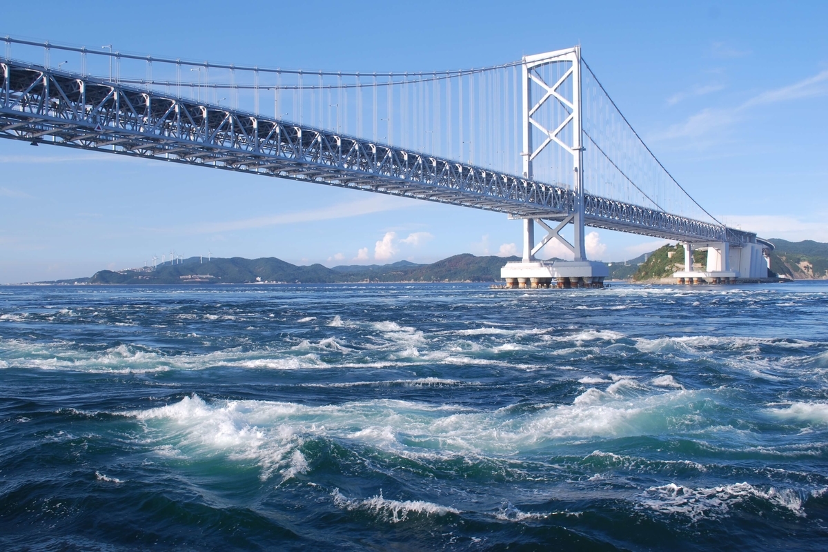
The calm waters of the Setonaikai Sea have areas with strong currents due to straits, and especially the strait between Naruto and Awaji Island that has a width of about 1.3 km. more
The calm waters of the Setonaikai Sea have areas with strong currents due to straits, and especially the strait between Naruto and Awaji Island that has a width of about 1.3 km. more
Naruto strait is one of the connections between the Pacific Ocean and the Inland Sea, separating two of the main islands of Japan, Honshu and Shikoku. The tide moves large amounts of water into the Inland Sea and removes large amounts of water offering you the possibility to experience a journey on a tidal current boat. The current in the strait is the fastest in Japan and reaches speeds of 37 km/h, creating whirlpools up to 20 m in diameter, known as the Naruto Whirlpools.
The Setonaikai Sea has prospered as the key junction of maritime traffic from long ago and the area has been populated by a great number of people creating scenes of old port towns, shrines and temples, and terraced fields utilizing inclined planes, where people live their lives in harmony with nature. There are many beautiful sandy beaches such as the Keino-Matsubara, Shibukawa Beach, Tsudano-Matsubara, Katsura Beach, Karako Beach, etc.
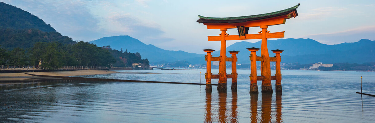
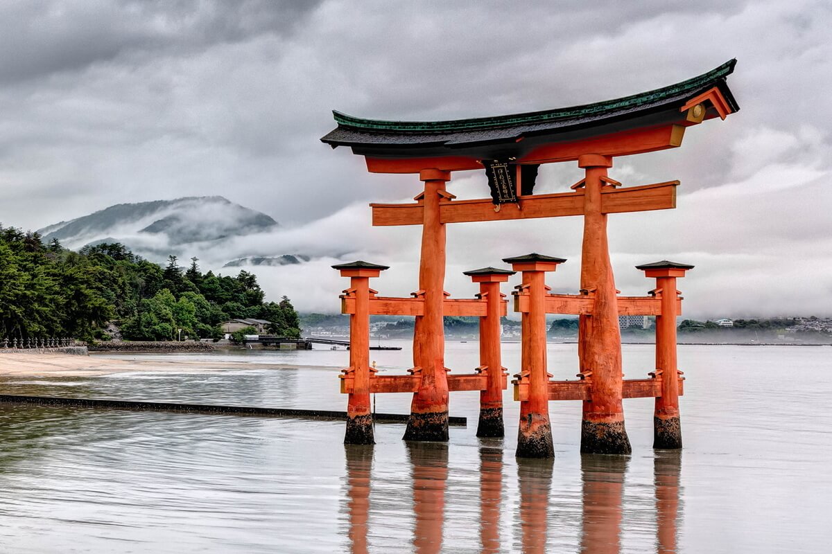
The sea boasts a wide range of biodiversity, being inhabited by rare creatures native to tidal flats, seagrass beds, rocky shores, and tidal marshes including finless porpoise, Japanese horseshoe crabs and Miyajima dragonfly that only lives on Miyajima Island, renowned as one of Japan’s three most scenic places.
The Setonaikai Sea has prospered as the key junction of maritime traffic from long ago and the area has been populated by a great number of people creating scenes of old port towns, shrines and temples, and terraced fields utilizing inclined planes, where people live their lives in harmony with nature. There are many beautiful sandy beaches such as the Keino-Matsubara, Shibukawa Beach, Tsudano-Matsubara, Katsura Beach, Karako Beach, etc.
The sea boasts a wide range of biodiversity, being inhabited by rare creatures native to tidal flats, seagrass beds, rocky shores, and tidal marshes including finless porpoise, Japanese horseshoe crabs and Miyajima dragonfly that only lives on Miyajima Island, renowned as one of Japan’s three most scenic places.
Daisen Oki National Park has an area of 35,353 ha (land area) and combines the Oki Islands and coastal areas of the Shimane Peninsula and the mountainous areas including Mt. Daisen, Mt. Hiruzen, Mt. Kenashi, Mt. Senjo and Mt. Mitoku.
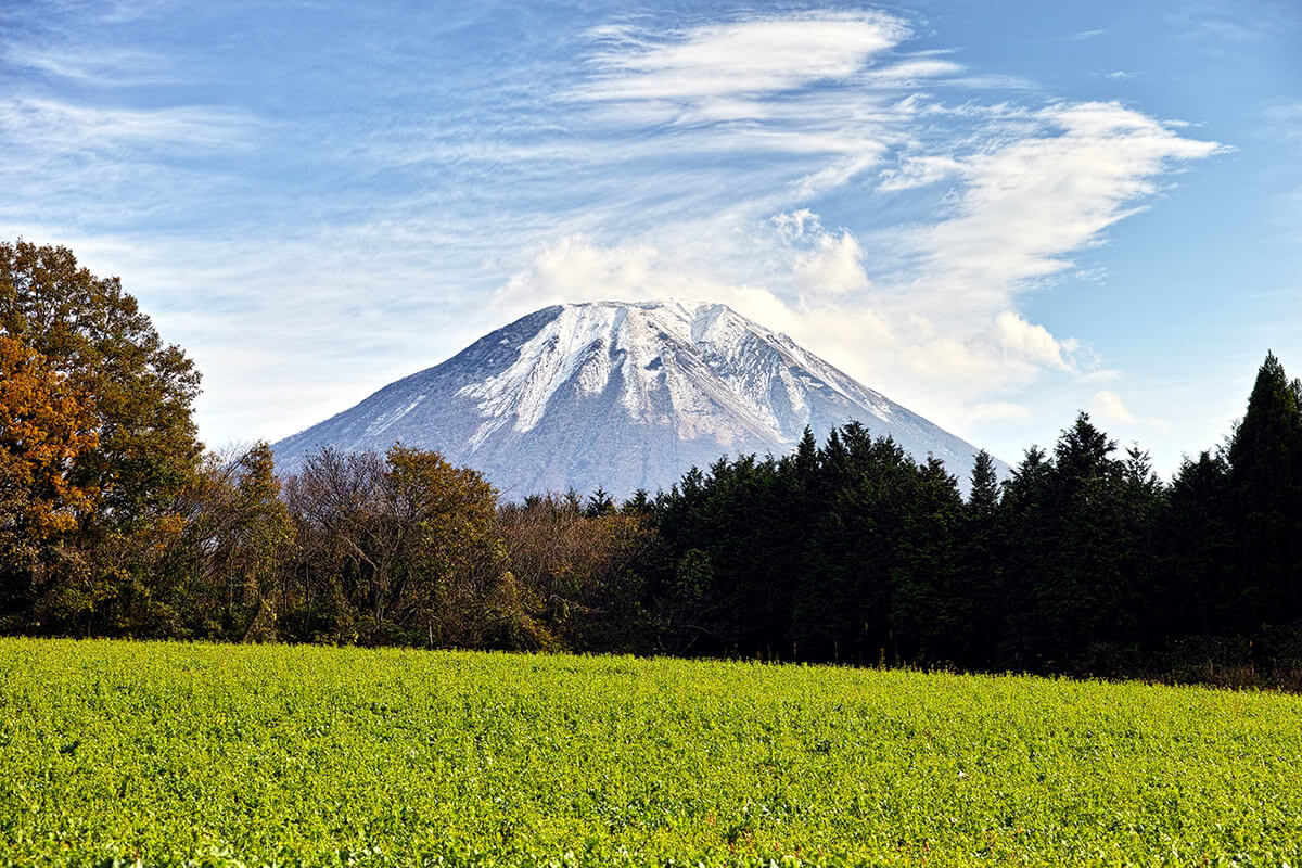
The mountainous areas consist of a diversity of elements including dynamic volcanic landforms, rich forests and a vast grass-covered plain. Mt. Daisen is a volcanic mountain and the highest peak in Chugoku region (1,729 m above sea level). It is covered with abundant forests including one of the largest natural beech forests in western Japan that spreads over the mountain at 800 m to 1,300 m above sea level. It is also an important spiritual icon and a popular hiking destination. Most of the other mountains are also densely forested including beech forests in Mt. more
The mountainous areas consist of a diversity of elements including dynamic volcanic landforms, rich forests and a vast grass-covered plain. Mt. Daisen is a volcanic mountain and the highest peak in Chugoku region (1,729 m above sea level). It is covered with abundant forests including one of the largest natural beech forests in western Japan that spreads over the mountain at 800 m to 1,300 m above sea level. It is also an important spiritual icon and a popular hiking destination. Most of the other mountains are also densely forested including beech forests in Mt. more
Kenashi and Mt. Sanbe, and also evergreen forest and cool-temperate forests in Mt. Mitoku.
The Shimane Peninsula is located across the Sea of Japan from Izumo to Sakaiminato and has many rocky shores that people cannot easily access, making it an ideal breeding ground for seabirds. Two sea water lakes, Lake Shinji and Nakaumi were created by the peninsula. Lake Shinji is a popular resort area including Matsue, the prefectural capital, located on the eastern shore of the lake.
The Oki Islands are a group of small and remote islands in the Sea of Japan, about 40-80 km off the north coast of Shimane Prefecture in the southwest of Honshu Island. They are volcanic islands (now extinct) and very mountainous islands with stunning eroded coastlines, created around 5-6 million years ago in the Sea of Japan. The island group consists of four inhabited islands that are the largest having a total population of less than 22,000 people. The largest island, Dogo is more distant and somewhat separated from the other three inhabited islands, Nishinoshima, Nakanoshima, and Chiburijima that are known as the three Dozen Islands and can be easily reached from each other by ferry. The charm of these islands lies in their remoteness from mainland Japan, unique culture and traditions, and of course the beautiful coastal scenery of the volcanic islands.