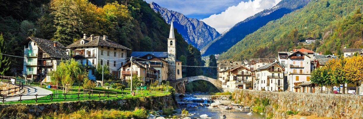

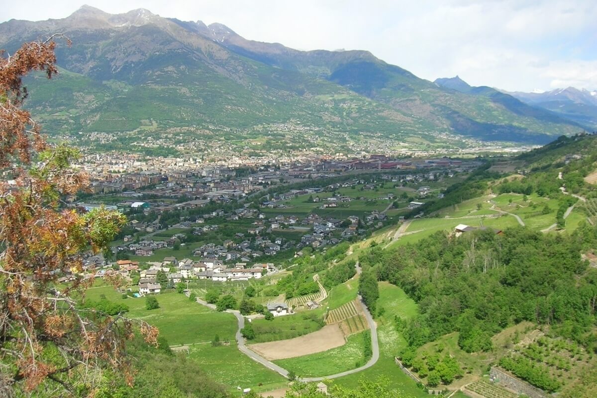
Aosta Valley is a mountainous region in the northwestern part of Italy, bordered by Auvergne-Rhône-Alpes (France) to the west, Valais (Switzerland) to the north and Piedmont (Italy) to the south and east. It is the smallest region in Italy covering an area of 3,263 km2 and least densely populated region with a population of about 128,000 inhabitants.
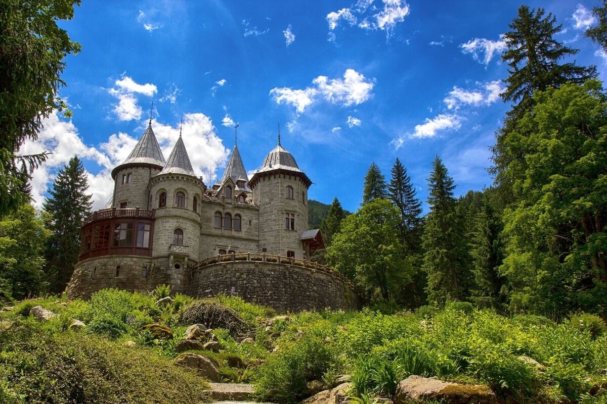
Aosta Valley includes the highest peaks in the Alps: Cervino, Monte Rosa, Gran Paradiso and Mont Blanc at 4,807.5 m (the highest mountain in Europe), making it the highest region in Italy. The region has various major ski resorts, including Courmayeur, one of the most important ski resorts in the world. In a beautiful setting of high mountains and diverse valleys sits the oldest park, Gran Paradiso National Park, where it is still possible to see animals such as ibex, more
Aosta Valley includes the highest peaks in the Alps: Cervino, Monte Rosa, Gran Paradiso and Mont Blanc at 4,807.5 m (the highest mountain in Europe), making it the highest region in Italy. The region has various major ski resorts, including Courmayeur, one of the most important ski resorts in the world. In a beautiful setting of high mountains and diverse valleys sits the oldest park, Gran Paradiso National Park, where it is still possible to see animals such as ibex, more
chamois, eagles and marmots in their natural habitat.
Historically, Aosta Valley has been viewed as land of contact between Italy and France and this is also reflected in its official bilingualism. Italian and French are the official languages of the region, though the native population also speak Valdôtain, a dialect of Arpitan (Franco-Provençal). 50.53% of the population can speak all three languages.
The capital and undisputed queen of the region is Aosta, the rampart of the ancient civilization of Rome. Surrounded by mountains, Aosta town combines ancient culture and amazing scenery. It was captured by the Romans from the Salassi in 25 BC and is still dotted with fine Roman architecture such as the Roman Theatre, the Roman Bridge and above all the Arch of Augustus, built in honour of Emperor Augustus. The town was once called Augusta Praetoria and its centre still consists of a network of large squares. There are as well more recent monuments such as the Church Complex of Sant’Orso and the Cathedral, showcasing the religious devotion of the city.
TOURIST ATTRACTIONS IN AOSTA
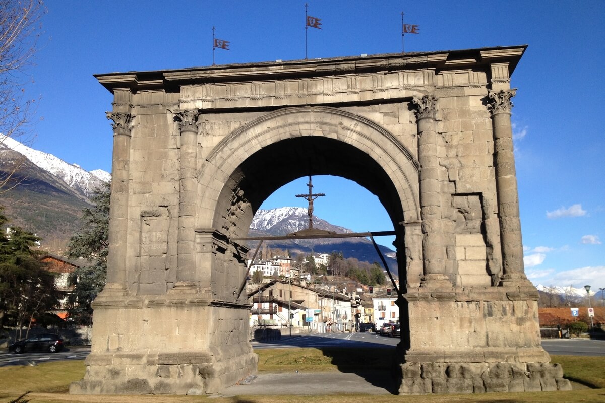
Arch of Augustus
In Roman times, the entry to Aosta was through the Arch of Augustus, a triumphal arch that used to be an eloquent sign of the presence and power of Rome. The arch measures 8.29 metres in width and has a single vault, with a height to the keystone of 11.4 metres. In the Medieval period, the arch was called “Saint-Voût” (French for Holy Arch) given the presence of an image of Jesus, which was located on it and then later replaced with the Crucifix.
The monument, which is characterised by its severe stateliness, has ten engaged columns that decorate its facade and its sides culminating in Corinthian capitals, while the entablature, adorned with metopes and triglyphs, is of the Doric order (one of the three orders of ancient Greek and later Roman architecture).
In 1716, because of the numerous leaks the Conseil des Commis decided to preserve the monument from the infiltration of water by replacing the attic that previously crowned the arch with a slate roof. The Arch was definitively restored between 1912-1913 under the direction of Ernesto Schiaparelli.
Porta Pretoria
Situated on the eastern section of the ancient city walls, between via Sant’Anselmo and via Porta Praetoria, Porta Pretoria provided the main access to the city of Augusta Praetoria and was built in 25 BC after the defeat of the Salassians by the Romans. It still is in an excellent state of conservation and has two series of arches (openings) - one major central arch and two minor lateral ones. The central one is for carriages and the side ones are for pedestrians. The area inside the arches (openings) was used as a troop parade court. In the Medieval Period, there was a chapel dedicated to the Most Blessed Trinity resting against Porta Praetoria, but now only an alcove of this chapel remains.
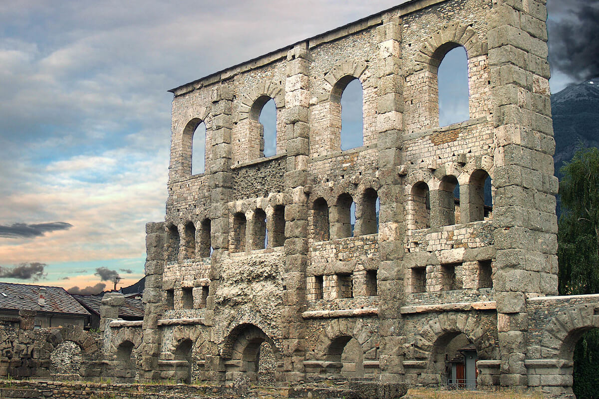
Roman Theatre
The Roman Theatre was built in the late reign of Augustus, some decades after the foundation of the city (25 BC) and is impressive due to its 22 m high southern façade with its overlapping arches. The theatre occupies three blocks annexed to the ancient city walls, along the Roman main road and could gather up to 3,500 - 4,000 spectators. The lower part of the semi-circle of steps that housed the spectators (cavea) and the foundations of the wall that acted as a backdrop (scaena) are still visible today. Since 2011, the theatre has been used for music shows and theatrical performances.
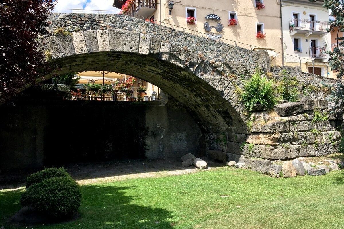
Roman Bridge
The Roman Bridge is a stone structure dated to the second half of the reign of Augustus (30 BC - 14 AD) that was of strategic importance, since in Aosta the transalpine routes to Gaul split into the Little St. Bernard and the Great St. Bernard Pass. The bridge sits above the ancient course of the Buthier River, which during the Middle Ages changed its course, leaving the ancient bridge without water.
The single-arch bridge has a span of 17.1 m and a width of 5.9 m and was built with blocks of stone, in compliance with the Roman models of the time. It characterises the eastern quarter of the city, called “Pont de Pierre” (Stone Bridge) and is still used as a thoroughfare today.
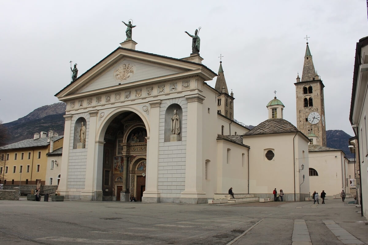
Santa Maria Assunta Cathedral (Cattedrale di Santa Maria Assunta)
Santa Maria Assunta Cathedral is a Roman Catholic cathedral built in the 4th century in Aosta and the episcopal seat of the Diocese of Aosta. In the 11th century, the Palaeo-Christian structure was replaced by a new one dedicated to the Assumption of the Virgin Mary, making Aosta one of the main centres of Ottonian art in Europe. The architecture of the cathedral was modified during the 15th and 16th century when the bishops of Aosta planned a radical restoration intervention on the church and enriched it with numerous works of art.
The facade of the cathedral consists of two different parts: an atrium dating back to the 16th century and a front section in neo-classical style added in 1848. The atrium has an elegant architectural design and is decorated with statues and frescoes depicting the life of the Virgin Mary, to whom the church is dedicated. It is a splendid example of renaissance art in Valle d’Aosta. Next door, the Treasure Museum contains a rich collection of statuettes, reliquaries and pieces from the Cathedral’s rich treasure providing a significant overview of the art of Valle d’Aosta between the 13th-18th centuries.
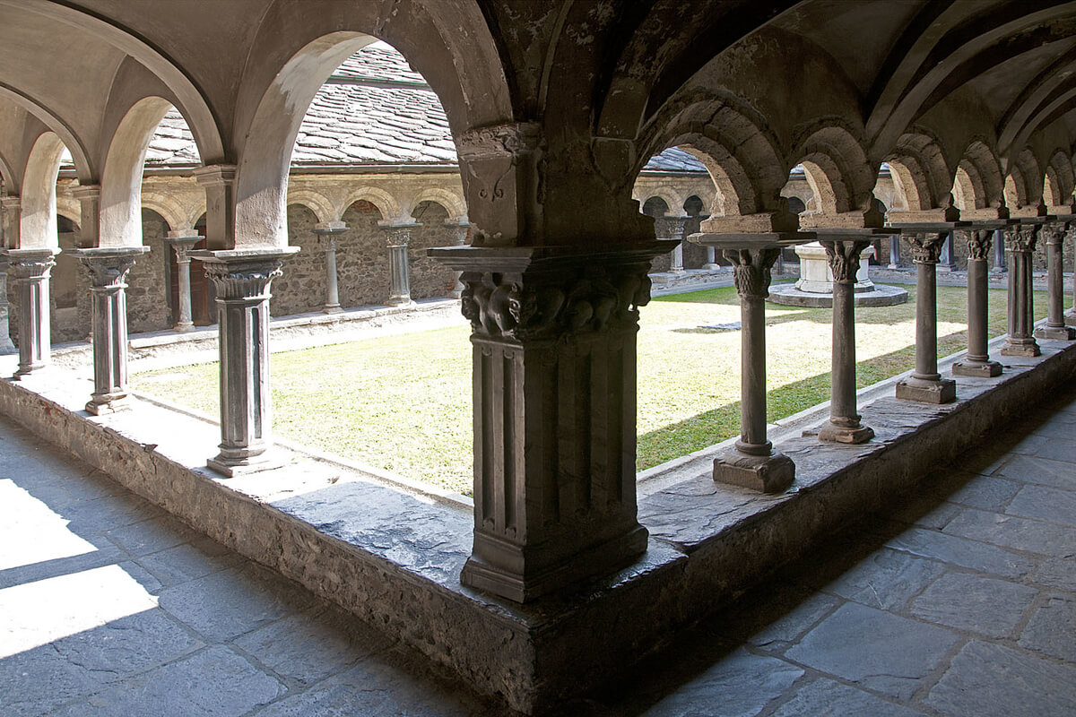
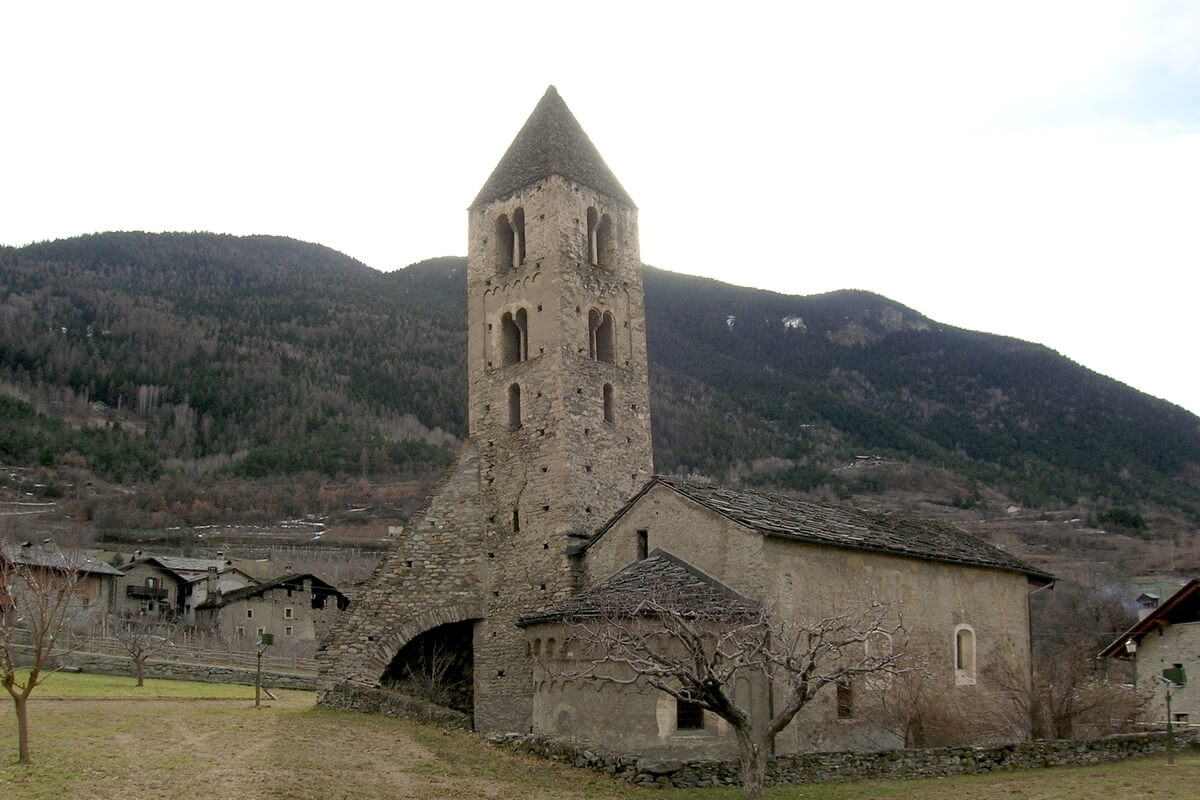
Church Complex of Sant’Orso
Located east of the town walls, the Church Complex of Sant’Orso dates back to the 5th century and includes the Collegiate Church of Saint Orso dedicated to Saint Ursus of Aosta with its Romanesque cloister, the Priory and the early Christian basilica.
The original church consisting of a single hall, delimited by a semi-circular apse was entirely rebuilt during the 9th century. Later, the bishop Anselm of Aosta renovated the church, promoting the Ottonian frescoes and introducing a basilica plan with three naves with wooden trusses. In the 15th century, these were replaced by Gothic cross vaults. The church has a Gothic façade, an interior with 11th-century frescoes and a crypt holding the tomb of St. Orso, patron saint of Aosta. Next to the collegiate church, the visitor can see the imposing Romanesque bell tower, 46 metres tall, originally a defence tower (half of the 12th century).
Located on the right hand side of the façade, the Romanesque cloister is the jewel of the monumental complex of Sant’Orso and almost certainly dates back to 1133. The cloister has historiated capitals sculpted in marble depicting scenes from the Old and New Testaments, from the life of Saint Orso. The capitals are considered to be among the utmost expressions of romanesque religious sculpture.
SIDE TRIPS FROM AOSTA
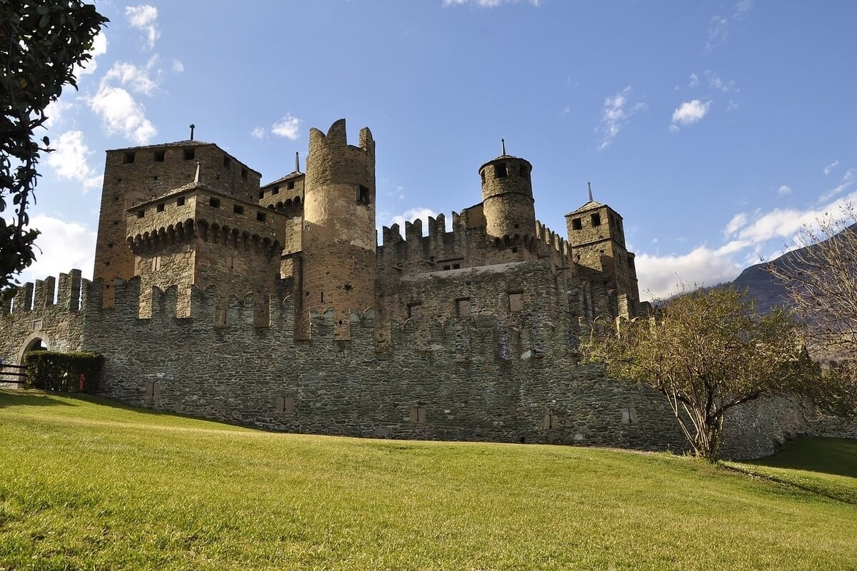
Fénis Castle (Castello di Fénis)
Located only 12 km east of Aosta in Fénis commune, Chez Sapin frazione (ward), the Fénis Castle has a well-preserved interior with frescoes and wooden galleries and is one of the most famous castles in Aosta Valley. The medieval castle is very much appreciated for its architecture and its many towers and battlemented walls and has become one of the major tourist attractions of the region.
The castle has three floors. On the ground floor it is possible to see the weaponry, the kitchen, the dining room, the woodshed and the storage tank to collect rainwater, while on the first floor there are the rooms of the lords of the castle, the chapel with frescoes by Giacomo Jaquerio and his school and the court. The second floor was dedicated to the servant's quarter and is not open to the public.
Unlike other castles built for military and defence purposes, the Fénis Castle is not situated on the top of a promontory or another inaccessible place, but rather on a small knoll. In fact, it was not built for military purposes, but to serve as the prestigious seat of the Challant family. Towards the middle of the 14th century, Aimone of Challant added many towers displaying surprising architectural harmony to the existing turret. Today the Regional Council owns the castle.
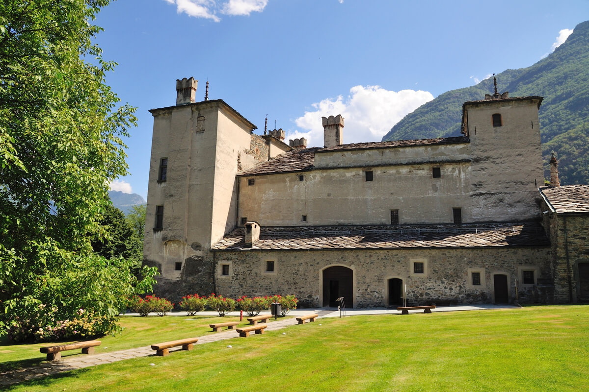
Issogne Castle (Castello di Issogne)
The Issogne Castle is a picturesque medieval castle located 38 km southeast of Aosta on the right bank of the Dora Baltea River in the centre of the inhabited area of Issogne commune, La Place frazione (ward). It is one of the most famous manors of the region and is most noteworthy for its fountain with a centrepiece in the shape of a pomegranate tree and its highly decorated portico with its frescoed cycle of scenes of daily life from the late Middle Ages, a rare example of medieval Alpine painting.
The castle has three floors. On the ground floor, there are the dining room, the kitchen and the Baron’s hall. The first floor houses the chapel with finely decorated, pointed arch vaults, frescoes on the walls and a Gothic altar and the Countess’s room with painted oratory. On the second floor, the “King of France’s room”, with a coffered ceiling adorned with lilies and the “Knights of St. Maurice” room with a nice, coffered ceiling with the Order’s cross tinted on it impress with their beauty. Starting from 2018, Avondo’s apartment, a new emotional space dedicated to the artist Vittorio Avondo, who bought the castle in 1872, restored it and donated it to the State in 1907, enriches the castle’s offer by highlighting its events of the late 19th century.
The current appearance of the castle developed between 1490 and 1510 under George of Challant, the prior of Sant’ Orso, who transformed it into a luxurious residence for his cousin Margaret de La Chambre and her son Philibert. Entering the castle, you can see the courtyard with the walls, painted with the coats of arms of the Challant family and of the dinasties related to them and the famous iron pomegranate fountain in the centre of it, symbol of the Challant family.
Historically, Aosta Valley has been viewed as land of contact between Italy and France and this is also reflected in its official bilingualism. Italian and French are the official languages of the region, though the native population also speak Valdôtain, a dialect of Arpitan (Franco-Provençal). 50.53% of the population can speak all three languages.
The capital and undisputed queen of the region is Aosta, the rampart of the ancient civilization of Rome. Surrounded by mountains, Aosta town combines ancient culture and amazing scenery. It was captured by the Romans from the Salassi in 25 BC and is still dotted with fine Roman architecture such as the Roman Theatre, the Roman Bridge and above all the Arch of Augustus, built in honour of Emperor Augustus. The town was once called Augusta Praetoria and its centre still consists of a network of large squares. There are as well more recent monuments such as the Church Complex of Sant’Orso and the Cathedral, showcasing the religious devotion of the city.
TOURIST ATTRACTIONS IN AOSTA
Arch of Augustus
In Roman times, the entry to Aosta was through the Arch of Augustus, a triumphal arch that used to be an eloquent sign of the presence and power of Rome. The arch measures 8.29 metres in width and has a single vault, with a height to the keystone of 11.4 metres. In the Medieval period, the arch was called “Saint-Voût” (French for Holy Arch) given the presence of an image of Jesus, which was located on it and then later replaced with the Crucifix.
The monument, which is characterised by its severe stateliness, has ten engaged columns that decorate its facade and its sides culminating in Corinthian capitals, while the entablature, adorned with metopes and triglyphs, is of the Doric order (one of the three orders of ancient Greek and later Roman architecture).
In 1716, because of the numerous leaks the Conseil des Commis decided to preserve the monument from the infiltration of water by replacing the attic that previously crowned the arch with a slate roof. The Arch was definitively restored between 1912-1913 under the direction of Ernesto Schiaparelli.
Porta Pretoria
Situated on the eastern section of the ancient city walls, between via Sant’Anselmo and via Porta Praetoria, Porta Pretoria provided the main access to the city of Augusta Praetoria and was built in 25 BC after the defeat of the Salassians by the Romans. It still is in an excellent state of conservation and has two series of arches (openings) - one major central arch and two minor lateral ones. The central one is for carriages and the side ones are for pedestrians. The area inside the arches (openings) was used as a troop parade court. In the Medieval Period, there was a chapel dedicated to the Most Blessed Trinity resting against Porta Praetoria, but now only an alcove of this chapel remains.
Roman Theatre
The Roman Theatre was built in the late reign of Augustus, some decades after the foundation of the city (25 BC) and is impressive due to its 22 m high southern façade with its overlapping arches. The theatre occupies three blocks annexed to the ancient city walls, along the Roman main road and could gather up to 3,500 - 4,000 spectators. The lower part of the semi-circle of steps that housed the spectators (cavea) and the foundations of the wall that acted as a backdrop (scaena) are still visible today. Since 2011, the theatre has been used for music shows and theatrical performances.
Roman Bridge
The Roman Bridge is a stone structure dated to the second half of the reign of Augustus (30 BC - 14 AD) that was of strategic importance, since in Aosta the transalpine routes to Gaul split into the Little St. Bernard and the Great St. Bernard Pass. The bridge sits above the ancient course of the Buthier River, which during the Middle Ages changed its course, leaving the ancient bridge without water.
The single-arch bridge has a span of 17.1 m and a width of 5.9 m and was built with blocks of stone, in compliance with the Roman models of the time. It characterises the eastern quarter of the city, called “Pont de Pierre” (Stone Bridge) and is still used as a thoroughfare today.
Santa Maria Assunta Cathedral (Cattedrale di Santa Maria Assunta)
Santa Maria Assunta Cathedral is a Roman Catholic cathedral built in the 4th century in Aosta and the episcopal seat of the Diocese of Aosta. In the 11th century, the Palaeo-Christian structure was replaced by a new one dedicated to the Assumption of the Virgin Mary, making Aosta one of the main centres of Ottonian art in Europe. The architecture of the cathedral was modified during the 15th and 16th century when the bishops of Aosta planned a radical restoration intervention on the church and enriched it with numerous works of art.
The facade of the cathedral consists of two different parts: an atrium dating back to the 16th century and a front section in neo-classical style added in 1848. The atrium has an elegant architectural design and is decorated with statues and frescoes depicting the life of the Virgin Mary, to whom the church is dedicated. It is a splendid example of renaissance art in Valle d’Aosta. Next door, the Treasure Museum contains a rich collection of statuettes, reliquaries and pieces from the Cathedral’s rich treasure providing a significant overview of the art of Valle d’Aosta between the 13th-18th centuries.
Church Complex of Sant’Orso
Located east of the town walls, the Church Complex of Sant’Orso dates back to the 5th century and includes the Collegiate Church of Saint Orso dedicated to Saint Ursus of Aosta with its Romanesque cloister, the Priory and the early Christian basilica.
The original church consisting of a single hall, delimited by a semi-circular apse was entirely rebuilt during the 9th century. Later, the bishop Anselm of Aosta renovated the church, promoting the Ottonian frescoes and introducing a basilica plan with three naves with wooden trusses. In the 15th century, these were replaced by Gothic cross vaults. The church has a Gothic façade, an interior with 11th-century frescoes and a crypt holding the tomb of St. Orso, patron saint of Aosta. Next to the collegiate church, the visitor can see the imposing Romanesque bell tower, 46 metres tall, originally a defence tower (half of the 12th century).
Located on the right hand side of the façade, the Romanesque cloister is the jewel of the monumental complex of Sant’Orso and almost certainly dates back to 1133. The cloister has historiated capitals sculpted in marble depicting scenes from the Old and New Testaments, from the life of Saint Orso. The capitals are considered to be among the utmost expressions of romanesque religious sculpture.
SIDE TRIPS FROM AOSTA
Fénis Castle (Castello di Fénis)
Located only 12 km east of Aosta in Fénis commune, Chez Sapin frazione (ward), the Fénis Castle has a well-preserved interior with frescoes and wooden galleries and is one of the most famous castles in Aosta Valley. The medieval castle is very much appreciated for its architecture and its many towers and battlemented walls and has become one of the major tourist attractions of the region.
The castle has three floors. On the ground floor it is possible to see the weaponry, the kitchen, the dining room, the woodshed and the storage tank to collect rainwater, while on the first floor there are the rooms of the lords of the castle, the chapel with frescoes by Giacomo Jaquerio and his school and the court. The second floor was dedicated to the servant's quarter and is not open to the public.
Unlike other castles built for military and defence purposes, the Fénis Castle is not situated on the top of a promontory or another inaccessible place, but rather on a small knoll. In fact, it was not built for military purposes, but to serve as the prestigious seat of the Challant family. Towards the middle of the 14th century, Aimone of Challant added many towers displaying surprising architectural harmony to the existing turret. Today the Regional Council owns the castle.
Issogne Castle (Castello di Issogne)
The Issogne Castle is a picturesque medieval castle located 38 km southeast of Aosta on the right bank of the Dora Baltea River in the centre of the inhabited area of Issogne commune, La Place frazione (ward). It is one of the most famous manors of the region and is most noteworthy for its fountain with a centrepiece in the shape of a pomegranate tree and its highly decorated portico with its frescoed cycle of scenes of daily life from the late Middle Ages, a rare example of medieval Alpine painting.
The castle has three floors. On the ground floor, there are the dining room, the kitchen and the Baron’s hall. The first floor houses the chapel with finely decorated, pointed arch vaults, frescoes on the walls and a Gothic altar and the Countess’s room with painted oratory. On the second floor, the “King of France’s room”, with a coffered ceiling adorned with lilies and the “Knights of St. Maurice” room with a nice, coffered ceiling with the Order’s cross tinted on it impress with their beauty. Starting from 2018, Avondo’s apartment, a new emotional space dedicated to the artist Vittorio Avondo, who bought the castle in 1872, restored it and donated it to the State in 1907, enriches the castle’s offer by highlighting its events of the late 19th century.
The current appearance of the castle developed between 1490 and 1510 under George of Challant, the prior of Sant’ Orso, who transformed it into a luxurious residence for his cousin Margaret de La Chambre and her son Philibert. Entering the castle, you can see the courtyard with the walls, painted with the coats of arms of the Challant family and of the dinasties related to them and the famous iron pomegranate fountain in the centre of it, symbol of the Challant family.
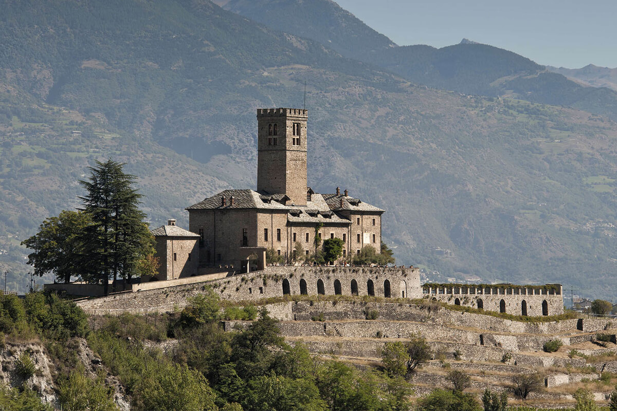
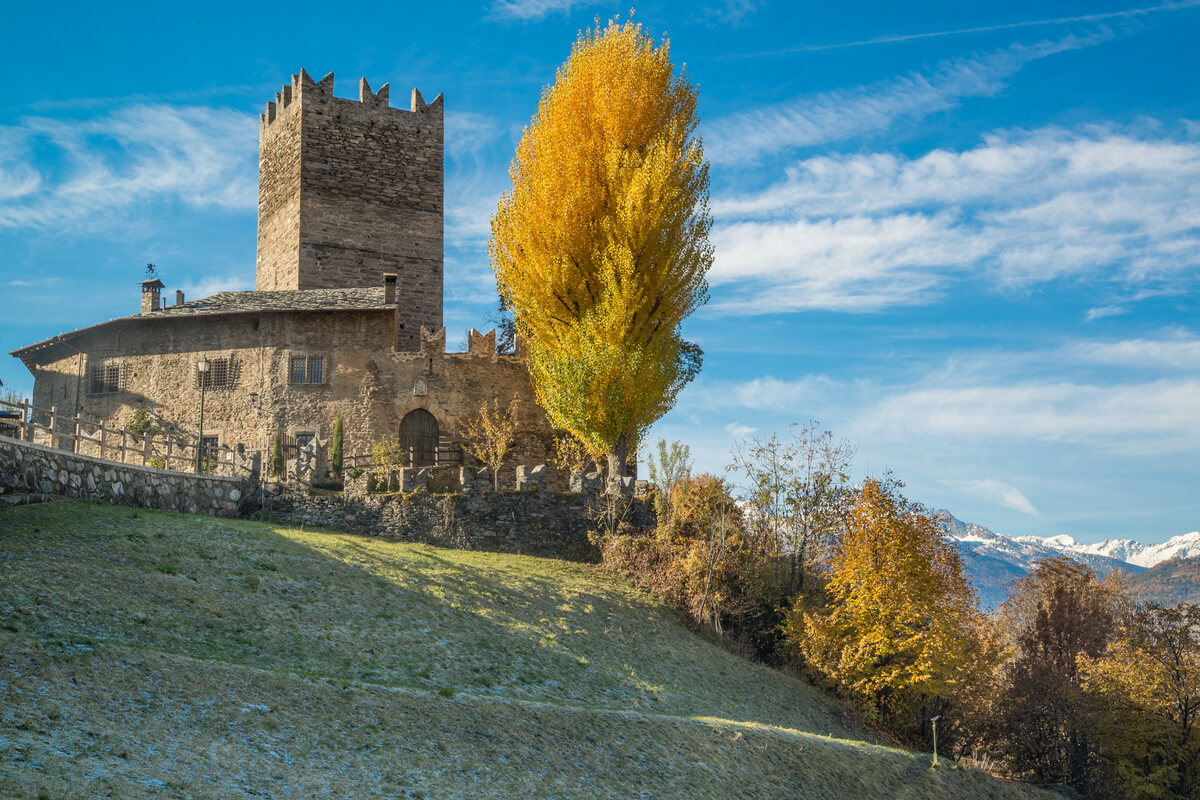
Situated at 631 metres above sea level, Sarre is a town and comune in Aosta Valley region. It offers good accommodation possibilities is often chosen by the tourists who look for easy access to the valleys of the Gran Paradiso National Park and the surroundings of Aosta. The territory extends over a very large area, which also reaches 3.061 meters of altitude of Mont Fallère, the tripoint connecting the Italian comunes of Sarre, Gignod and Saint-Pierre. The trekking lovers can reach the summit of Mont Fallère starting from the hamlet of Thouraz, while the mountain bike or on horseback lovers can opt for several routes in the area of Ville-sur-Sarre.
TOURIST ATTRACTIONS IN SARRE
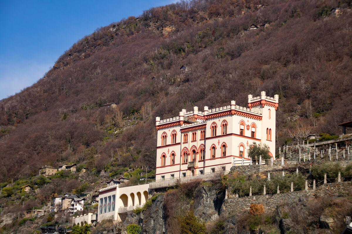
Sarre Royal Castle (Castello Reale di Sarre)
The Sarre Royal Castle was built in 1710 on the ruins of a fortress mentioned documentarily as early as 1242. more
TOURIST ATTRACTIONS IN SARRE
Sarre Royal Castle (Castello Reale di Sarre)
The Sarre Royal Castle was built in 1710 on the ruins of a fortress mentioned documentarily as early as 1242. more
It stands on a promontory in Sarre commune, Lalex frazione (ward), overlooking the Aosta flatland above the national road for Mont Blanc. After becoming the private property of the first king of Italy, Victor Emmanuel II, in 1869, the Sarre Royal Castle was used as his headquarters for expeditions in the valleys of Cogne, Rhêmes and Valsavarenche.
The regional authority of Valle d’Aosta purchased the estate in 1989 to restore it and today it is a museum where the presence of the Savoy dynasty in the region can be seen. The rooms on the second floor retrace, with their furnishings and portraits, the history of the Savoy dynasty during the 20th century. A hall for 112 people is available for meetings or exclusive evenings.
Parish Church of Saint-Maurice
The Parish Church of Saint-Maurice was built in 1643 and was extended in 1896 in Saint-Maurice frazione (ward) of Sarre commune. From the ancient church remains the semi-circular apse, where you can admire the remarkable frescoes made around 1430, attributed to Giacomino da Ivrea. The church underwent substantial changes over time, in particular at the end of ‘800, when on the initiative of the parish priest Thomas Lale Murix of Saint-Pierre it was lengthened by 5 metres and raised by approximately 1.20 metres. In the premises of the Parish Church of Saint-Maurice there are sacred art objects such as wooden sculptures, goldsmiths and fabrics, which come from the chapels of Ville-sur-Sarre, Bellun, Champé, as well as from the parish church itself. The highlights of the church are the coloured wooden statue of Saint Maurice on horseback from the early 15th century, a splendid painted wooden statue from the 14th-15th century, unique among Aosta Valley for its verticality, three processional crosses and numerous gilded silver chalices of exquisite workmanship and three reliquaries dating from the 14th to the 17th century.
“Sources du Ruet” picnic area
“Sources du Ruet” picnic area represents a mature woodland consisting of Scotch pine, Larch and Fir trees and a few broad-leaved trees such as Willow and Trembling Aspen. You can reach the area by taking the road leading from Sarre up to Ville-sur-Sarre frazione (ward) and reaching the Bellon frazione (ward). The access to the area is free, but wood is not provided.
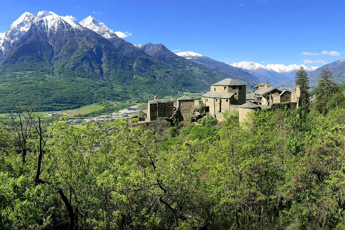
Situated at an altitude of 536 metres, Quart is a town and commune in Aosta Valley region. The name Quart is of Roman origin and indicates the distance of 4 miles from Aosta. The territory of Quart is very wide and scattered in many hamlets for which the agriculture plays an important role, favoured by the particularly sunny position. Quart is also known for its viticulture and flourishing production of high quality wines, as well as the famous Fontina cheese. The name Fontina could be traced back to the name of a mountain pasture belonging to the municipality of Quart - Alpe Fontin - where this cheese was created in the 13th century. Fontina cheese is made from unpasteurized cow's milk, has a soft texture with a minimal number of holes and a subtle taste of nuts and since 1996 has a certified label of origin.
TOURIST ATTRACTIONS IN QUART
Quart Castle
The Quart Castle is a castle in Quart commune, more
TOURIST ATTRACTIONS IN QUART
Quart Castle
The Quart Castle is a castle in Quart commune, more
Villair frazione (ward) that was built starting from 1185 by Jacques de la Porte de Saint-Ours, founder of the Lords of Quart. The castle is a set of buildings arranged within a fortified perimeter and initially had a military defence purpose at the gates of the east village of Aosta. Around the end of the 14th century, the castle passed to the Lords of Savoy who used it as a residential dwelling until 1550, when it was sold to Philibert Laschis who in turn sold it almost immediately to Charles-François Balbis. In the 17th century, the castle belonged first to Count Nicholas Coardo and then passed to the Perrone of San Martino, who gave it to the Municipality of Quart in 1800. The castle houses valuable examples of architecture and painting that range from the 12th century to the 17th century.
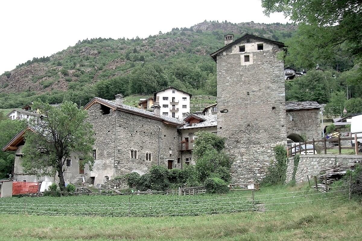
Fortified House of Povil (Casaforte di Povil)
The Fortified House of Povil (Casaforte di Povil) is a fortified medieval complex located on the hill of Quart commune, Povil frazione (ward) and originally belonged to the lords of Quart. In the second half of the 14th century, the complex was purchased by Jean-Michel Piquart, lord of the manor of Quart at the time and a member of the La Tour family of Courmayeur being transferred to Carlo Filippo Perrone, baron of Quart in 1680.
On the eastern side of the complex, the tower has a remarkable arched door and carved stone windows. The main housing body with two windows in the Gothic style overlooks the internal courtyard and has the Piquart de la Tour coat of arms, dated 1627 at the entrance.
Neolithic Vollein Necropolis
On the slopes below the Quart Castle, in the Les Cleyyes area in Vollein frazione (ward), Quart commune, remains of the Neolithic Vollein necropolis were found in 1968. They are considered one of the first traces of human settlement in Aosta Valley and include more than 60 chest-shaped tombs from the Ice Age and rupestrian engravings dating back to the II millennium BC. The geological site of Vollein has some extremely significant geological, geomorphological and cultural aspects within a limited surface area.

Pont-Saint-Martin is a town and commune in Aosta Valley region, home of the notable Pont-Saint-Martin Roman Bridge and two ruined medieval castles (Pont-Saint-Martin Castle and Suzey Castle). The communal territory is crossed by the Lys River and is surrounded by greenery, hundred-year-old chestnut and birch trees in the park area Bousc Daré.
TOURIST ATTRACTIONS IN PONT-SAINT-MARTIN
Pont-Saint-Martin Castle
About a kilometre after the park area Bousc Daré, you can see the remains of the Pont-Saint-Martin Castle, which is also known as Castellaccio or Castello Vecchio (Old Castle). The oldest part of the building is the primitive hexagonal wall that contained a probable original keep (donjon) which has now disappeared and could date back to the 11th century. more
Entering the castle through a door protected by slits, you can see on the left a housing building dating back to the 13th-14th century, with large cross windows.
Suzey Castle
Suzey Castle is a medieval castle now in ruins, located upstream from the hamlet of Ivéry in Pont-Saint-Martin commune. Raised on a modest rocky promontory, it overlooks Ivéry and is situated near the Holey Pond Nature Reserve, a very popular space protected due to its very interesting flora. Even if it seems to proceed from an ancient heritage, the castle had been mentioned regularly since the 14th century in the feudal recognitions of the noble and powerful family of the Vallaise, a family that had several possessions in the region. The castle, which is today completely in ruins, was characterized by the presence of a circular tower, now destroyed, which, according to recent studies, was 5 metres in diameter, and which could have been built in the 12th or 13th century.
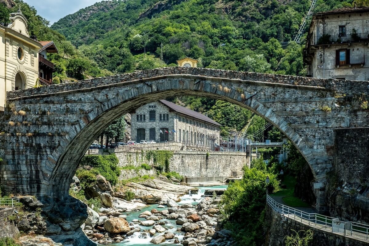
Pont-Saint-Martin Bridge
The Pont-Saint-Martin Bridge is a Roman bridge in Pont-Saint-Martin commune and dates back to the 1st century BC. It is 25 metres high and is anchored in rock on both sides, has a span of 31.4 metres and a single arch, which is 35 metres wide. At its base, dug into the living rock, you can see the bearings for the wooden beams that provided the necessary framework for the construction of the stone arch. At the end of the 19th century, some iron crowns were added to strengthen the structure.
Baraing Castle
The construction of Barraing Castle began in 1883 on a rock overlooking the ancient burg, by a local doctor and philanthropist, Pietro Annibale Baraing, one of the most important figures in Pont-Saint-Martin, after his marriage to Delfina Bianco. It was built in neo-gothic style, and was surrounded by a large garden with greenhouses and fountains. Its construction was completed in 1893 and in 1931 it was donated to the municipality of Pont-Saint-Martin, which turned it into the town hall. Now it is the headquarters of the Comunità Montana Mont Rose (Mont Rose Mountain Community).
SIDE TRIPS FROM PONT-SAINT-MARTIN
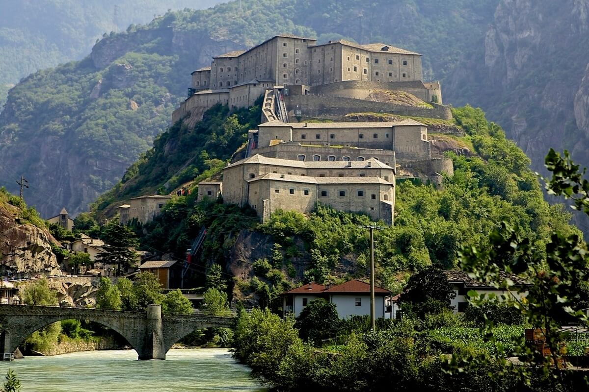
Bard Fortress
Located only 5 km from Pont-Saint-Martin, Bard Fortress stands at the entrance to the region of Valle d'Aosta in Bard commune and has a long and glorious history. The fortress originally served as a control point of the Alpine routes leading from France to Italy. The military reinforcement of the Alpine crossings began in the early 4th century AD and lasted for many centuries after that. In 1034, it appears as “inexpugnabile oppidum” in one of the oldest references in Valle d’Aosta. In 1241, the Lords of Bard handed over the fortress to the Counts of Savoy, who had since then ruled the domain. In May 1800, Napoleon Bonaparte found a garrison of 400 Austrian men within the fortress. The defence structures of the fort were so efficient that it took about two weeks to Napoleon’s army to overcome the Austrian defence, after which the fortress was dismantled by Napoleon, to avoid further problems.
The current look of the fortress is the result of the reconstruction work commissioned by Carlo Felice, who from 1830 onwards, turned it into one of the largest military structures in Aosta Valley. It ceased to be a military state property in 1975 and was purchased by the Aosta Valley regional authority in 1990. Completely renewed in 2006, the fortress houses the Museum of the Alps, which is a prestigious cultural centre, with realistic multimedia simulations and audiovisual presentations of Bard, as well as various permanent and temporary exhibitions.
Verrès Castle
Not far from Pont-Saint-Martin (about 15 km) is Verrès, a town and commune of Roman origin and the location of the Verrès Castle. It is a recently-restored 14th-century military castle whose construction was completed in 1390 by Ibleto di Challant, a member of one of the most important noble families in Aosta Valley. This single-block castle is the perfect combination between the majestic essentiality of a fortress with the elegance of a castle and is refined with rich decorations on the doors, windows and monumental fireplaces.
In 1536, Renato of Challant renovated the defence structures, adapting them for modern firearms. On this occasion, a boundary wall with a battery, buttresses and five-sided attack towers were installed and protection was given to the entrance with the addition of an inner gate, a drawbridge and loopholes. New cross windows were created and new gates with Spanish-inspired Moorish arches appeared.
In 1565, the castle was taken over by the Savoy and in 1661, Duke Charles Emmanuel II ordered the dismantling of weapons and their transfer to the fortress in Bard, a strategic defence point of Aosta Valley. The Challant regained the possession of the castle in 1696 and kept it until the end of the family line at the beginning of the 19th century. At that time, the castle had been abandoned for almost two centuries and was rescued later by a group of Piedmont intellectuals with a common love for the Middle Ages. Each year the castle is the backdrop for the Historic Carnival of Verrès.
Savoy Castle
Located about 28 km north of Pont-Saint-Martin in a panoramic wood setting in Gressoney-Saint-Jean commune, Savoy Castle was the chosen summer residence of Queen Margherita of Savoy. The castle was built between 1899 and 1904 at the foot of Ranzola hill in the place known as “Belvedere”, which dominates the whole valley up to the Lyskamm glacier. It has a central rectangular body, 5 different little cuspidate towers and a luxurious rock garden, home to botanical species that are typical among the alpine flora, as well as rare, scented herbs. The exterior is covered in grey stone from the quarries of Chiappey in Gressoney, Gaby and Vert.
The medieval-style castle was designed by the architect Emilio Stramucci, who also designed the neo-baroque decorations for Palazzo Reale in Turin and for the Quirinale in Rome. The distinctive features of the castle are its eclectic style, decorated wood ceilings and friezes and the enormous staircase. The neo-gothic style is also used in the so-called “staff-bearer’s entrance” in the octagonal tower which stands in the north-west corner. In 1981 the castle was purchased by the Aosta Valley Regional Council.
Suzey Castle
Suzey Castle is a medieval castle now in ruins, located upstream from the hamlet of Ivéry in Pont-Saint-Martin commune. Raised on a modest rocky promontory, it overlooks Ivéry and is situated near the Holey Pond Nature Reserve, a very popular space protected due to its very interesting flora. Even if it seems to proceed from an ancient heritage, the castle had been mentioned regularly since the 14th century in the feudal recognitions of the noble and powerful family of the Vallaise, a family that had several possessions in the region. The castle, which is today completely in ruins, was characterized by the presence of a circular tower, now destroyed, which, according to recent studies, was 5 metres in diameter, and which could have been built in the 12th or 13th century.
Pont-Saint-Martin Bridge
The Pont-Saint-Martin Bridge is a Roman bridge in Pont-Saint-Martin commune and dates back to the 1st century BC. It is 25 metres high and is anchored in rock on both sides, has a span of 31.4 metres and a single arch, which is 35 metres wide. At its base, dug into the living rock, you can see the bearings for the wooden beams that provided the necessary framework for the construction of the stone arch. At the end of the 19th century, some iron crowns were added to strengthen the structure.
Baraing Castle
The construction of Barraing Castle began in 1883 on a rock overlooking the ancient burg, by a local doctor and philanthropist, Pietro Annibale Baraing, one of the most important figures in Pont-Saint-Martin, after his marriage to Delfina Bianco. It was built in neo-gothic style, and was surrounded by a large garden with greenhouses and fountains. Its construction was completed in 1893 and in 1931 it was donated to the municipality of Pont-Saint-Martin, which turned it into the town hall. Now it is the headquarters of the Comunità Montana Mont Rose (Mont Rose Mountain Community).
SIDE TRIPS FROM PONT-SAINT-MARTIN
Bard Fortress
Located only 5 km from Pont-Saint-Martin, Bard Fortress stands at the entrance to the region of Valle d'Aosta in Bard commune and has a long and glorious history. The fortress originally served as a control point of the Alpine routes leading from France to Italy. The military reinforcement of the Alpine crossings began in the early 4th century AD and lasted for many centuries after that. In 1034, it appears as “inexpugnabile oppidum” in one of the oldest references in Valle d’Aosta. In 1241, the Lords of Bard handed over the fortress to the Counts of Savoy, who had since then ruled the domain. In May 1800, Napoleon Bonaparte found a garrison of 400 Austrian men within the fortress. The defence structures of the fort were so efficient that it took about two weeks to Napoleon’s army to overcome the Austrian defence, after which the fortress was dismantled by Napoleon, to avoid further problems.
The current look of the fortress is the result of the reconstruction work commissioned by Carlo Felice, who from 1830 onwards, turned it into one of the largest military structures in Aosta Valley. It ceased to be a military state property in 1975 and was purchased by the Aosta Valley regional authority in 1990. Completely renewed in 2006, the fortress houses the Museum of the Alps, which is a prestigious cultural centre, with realistic multimedia simulations and audiovisual presentations of Bard, as well as various permanent and temporary exhibitions.
Verrès Castle
Not far from Pont-Saint-Martin (about 15 km) is Verrès, a town and commune of Roman origin and the location of the Verrès Castle. It is a recently-restored 14th-century military castle whose construction was completed in 1390 by Ibleto di Challant, a member of one of the most important noble families in Aosta Valley. This single-block castle is the perfect combination between the majestic essentiality of a fortress with the elegance of a castle and is refined with rich decorations on the doors, windows and monumental fireplaces.
In 1536, Renato of Challant renovated the defence structures, adapting them for modern firearms. On this occasion, a boundary wall with a battery, buttresses and five-sided attack towers were installed and protection was given to the entrance with the addition of an inner gate, a drawbridge and loopholes. New cross windows were created and new gates with Spanish-inspired Moorish arches appeared.
In 1565, the castle was taken over by the Savoy and in 1661, Duke Charles Emmanuel II ordered the dismantling of weapons and their transfer to the fortress in Bard, a strategic defence point of Aosta Valley. The Challant regained the possession of the castle in 1696 and kept it until the end of the family line at the beginning of the 19th century. At that time, the castle had been abandoned for almost two centuries and was rescued later by a group of Piedmont intellectuals with a common love for the Middle Ages. Each year the castle is the backdrop for the Historic Carnival of Verrès.
Savoy Castle
Located about 28 km north of Pont-Saint-Martin in a panoramic wood setting in Gressoney-Saint-Jean commune, Savoy Castle was the chosen summer residence of Queen Margherita of Savoy. The castle was built between 1899 and 1904 at the foot of Ranzola hill in the place known as “Belvedere”, which dominates the whole valley up to the Lyskamm glacier. It has a central rectangular body, 5 different little cuspidate towers and a luxurious rock garden, home to botanical species that are typical among the alpine flora, as well as rare, scented herbs. The exterior is covered in grey stone from the quarries of Chiappey in Gressoney, Gaby and Vert.
The medieval-style castle was designed by the architect Emilio Stramucci, who also designed the neo-baroque decorations for Palazzo Reale in Turin and for the Quirinale in Rome. The distinctive features of the castle are its eclectic style, decorated wood ceilings and friezes and the enormous staircase. The neo-gothic style is also used in the so-called “staff-bearer’s entrance” in the octagonal tower which stands in the north-west corner. In 1981 the castle was purchased by the Aosta Valley Regional Council.

Gressan is a town and commune in Aosta Valley region, only 5 km away from Aosta town. It lies among wide orchards in the vast flat area of Aosta and was already inhabited during the Roman period. It is known for its towers and the religious buildings dating back to the Middle Ages that host some precious but uncommon artistic treasures, for Pila, both a ski resort and a significant destination for mountain bike, as well as for the excellent apple cultivation.
TOURIST ATTRACTIONS IN GRESSAN
Church of Sainte-Marie-Magdeleine
The Romanesque Church of Sainte-Marie-Magdeleine also known as “La Magdeleine Chapel” is situated in Gressan commune, Favret frazione (ward) and is surrounded by flourishing orchards. The church was built in the 12th century and from the 14th to the 16th century, more
the church was rebuilt and endowed with new frescoes by the noble family La Tour de Villa. Some charming frescoes dating back to 1463, both inside and outside, were realised by Giacomino d’Ivrea. The church consists of an apse and a 12th century Romanesque bell-tower supported by a characteristic buttress, while the nave was extended in 1460. In 1786, the parish of Sainte-Marie-Magdeleine became part of the parish of Santo Stefano and since then the church has been confined to the role of chapel.
La Tour de Villa Castle
La Tour de Villa Castle stands a bit higher than the Church of Sainte-Marie-Magdeleine, in a dominant position between orchards and vineyards in Gressan commune, Tour de Villa frazione (ward). It was built entirely on granite rock and its most ancient part is the impressive 24-metre medieval tower with a square plan that reproduce the Roman scheme. Originally, La Tour de Villa Castle was comprised almost entirely of the central tower, but today the complex is made up of two different parts: the 12th-century tower and the semi-circular residential building dating back to the 14th century. The name of the castle is due to the union of two ancient noble families of Aosta Valley, the La Tour and the De Villa, who had the rank of Pari. At present, it hosts an accommodation structure and sometimes even small events.
Maison Gargantua
Maison Gargantua is an ethnographic museum, an exhibition hall, an educational space, a sculpture laboratory and the departure point for discovering the surrounding territory. A visit to the Maison will make you discover the ancient folk wisdom thanks to objects, pictures and decorations showing ancient local customs and traditions, which are a significant part of the autochthonous culture. Maison Gargantua of Gressan awaits you for an eco-demoanthropological journey, a synthesis of alpine civilization, in a natural setting that presents an unsuspected biological diversity.
Côte de Gargantua Nature Reserve
Côte de Gargantua Nature Reserve has a surface area 19 hectares, altitudes between 610 and 776 m and is a typical well-preserved evidence of the deposits left by the Wurmian Quaternary glaciers on bottom of the main valley. Located near the Dora Baltea River, it appears like an elongated accumulation extending from south to northeast with a sharp summit and steep slopes. The reserve is interesting in itself from a geological and naturalistic point of view offering from its top a broad view of the urbanized and cultivated area of Gressan.
It is a good starting point for people interested to discover plants, flowers, fauna and waterways. The protected area’s xerothermic aspects (dry and sunny grassy-rocky slopes and peaks) provides the right environment for unique steppe plants such as the Artemisia vallesiaca (a rare aromatic plant) or the European goldilocks and species of Mediterranean origin, such as Uva Ursi, Linaria Simplex and the rare Alpine Daphne. The fauna mainly consists of reptiles, birds of prey, songbirds and small rodents.